Smart growth and other forms of growth-management planning create artificial housing shortages that impose significant burdens on low-income families and first-time homebuyers. This paper examines several sources of housing data to determine the specific effects of growth-management planning on housing prices.
Data examined include:
- Median family income and median value of owner-occupied homes by metropolitan area from the 1960 through 2000 censuses (the data actually apply to the year before each census, i.e., 1959, 1969, etc.);
- Median family income by metropolitan area estimated by the Department of Housing and Urban Development for 2005;
- Home price indices calculated for each metropolitan area by the Department of Commerce.
For each census year, housing affordability in each metropolitan area is estimated by calculating the number of years a median-income family devoting 25 percent of its income would need to pay off a mortgage equal to 90 percent of the value of a median-value home at mortgage interest rates prevailing at the time of the census. The same calculation is made for 2005 by updating the 1999 median home values using the Department of Commerce home price index. Mortgages that can be paid off in less than twenty years are judged affordable; twenty to thirty years is marginally affordable; and more than thirty years is unaffordable.
Comparing the results with the dates that cities or metropolitan areas begin doing growth-management planning reveals a remarkably consistent pattern. In most regions that have not done growth-management planning, long-term, inflation-adjusted housing prices grow at only about 1 percent per year. But prices almost invariably start growing much faster soon after regions begin growth-management planning.
In 1959 and 1969, almost every metropolitan area outside of Hawaii had affordable housing. Cities in California and the New York metropolitan area began experimenting with growth-management planning in the early 1970s, and by 1979 these cities were unaffordable. As more cities and regions began such planning, they too became unaffordable: the Boston area in the 1980s, the Denver area in the 1990s, and Florida cities in the early 2000s.
Housing prices have dramatically increased in the past six or seven years, but this increase has not been uniform across the nation. In general, regions with growth-management planning have seen prices increase by 4 to 14 percent per year. Regions without such planning have seen prices increase by only 1 to 3 percent per year.
Factors other than planning, such as a genuine shortage of private land available for development, appear to be responsible for high housing prices in only a handful of areas. In more than 110 metropolitan areas, higher home prices are the penalty paid by people who live in regions that use smart-growth planning.
This paper estimates this planning penalty in each metropolitan area by comparing the ratio of the median home value to the median family income in each metropolitan area with a standard ratio calculated to represent what housing costs would be without restrictive planning. For the census years, the standard ratio is the median ratio for all metropolitan areas. For 2005, the standard ratio assumes that, without growth-management planning, housing prices would have increased by 2.5 percent per year since 1999.
In a few areas that have recently adopted smart-growth plans, such as Jacksonville, Florida and Charleston, South Carolina, the planning penalty may still be under $10,000 per median-value home. But for most areas it is much more. The penalties in Boulder, Colorado and the San Francisco Bay Area, which pioneered this type of planning in the 1970s, exceed $500,000 per home. The penalty exceeds $100,000 per home in fifty metropolitan areas and ranges from $25,000 to $100,000 in fifty more.
More than 30 percent of the total value of homes in this country is attributable to prices inflated by planning-induced housing shortages. In 2005, homebuyers nationwide paid an estimated $275 billion more for homes because of restrictive planning. This does not count the added costs to renters or purchasers of commercial, industrial, or retail land.
Focus on California
Thanks in large part to urban planning, California suffers from having the least affordable housing in the nation. This report shows that California’s land-use planning system forces homebuyers to pay penalties ranging from $70,000 per median-value home in Bakersfield to $850,000 per home in the San Francisco metropolitan area. Indeed, Californians must pay fully half the total cost that planning imposes on homebuyers in the US.
These numbers are proof of Woodie Guthrie’s old song, “if you ain’t got the dough re mi,” you better not try to live in California. Yet many newcomers and young people will be surprised to learn that California cities, even San Francisco, were completely affordable as recently as 1970. It is only the use of growth-management techniques that California pioneered in the 1970s, including urban growth boundaries, greenbelts, and annual limits on building permits, that made California housing unaffordable.
Planning advocates argue that growth boundaries, greenbelts, and other restrictions are needed to preserve livability. But any benefits of these rules are dwarfed by the $2.7 trillion cost that planning-induced housing shortages have imposed on California homebuyers. In 2005 alone, homebuyers paid penalties totaling at least $136 billion for the privilege of owning a home in California.
The benefits of protecting open space are particularly questionable. Even though California is the nation’s most heavily populated state, the 2000 census found that nearly 95 percent of its people live in cities and towns that occupy just 5 percent of its land. Many San Francisco Bay Area counties have permanently protected more acres as open space than they have made available for urban development. When such actions make it impossible for middle-class families, much less low-income families, to afford their own homes, they represent a sad distortion of social priorities.
Existing homeowners may be grateful that planning restrictions have increased the value of their homes. But not all homeowners will be able to take advantage of this increased value. Those who wish to trade up to a larger or better home will face obstacles as great as those confronting first-time homebuyers. Those who need to move from, say, Sacramento, which is merely severely unaffordable, to the San Francisco Bay Area, which is extremely unaffordable, will encounter similar difficulties. Overall, the people who lose from such planning rules greatly outnumber the winners.
Moreover, as happened in the 1980s, California’s fast-rising home prices have attracted speculators who have created huge bubbles in the state’s housing markets. The chart on page 14 shows that California’s prices have careened wildly up and down and are poised for another gigantic fall.
The deflation of the current bubble is likely to be more severe than the 1990 bubble because prices today are even more out of line from fundamentals than they were then. This decline will force many families into bankruptcy when they find that the amount they still owe on their mortgages exceeds the true value of their homes.
The impacts of high housing prices reverberate throughout California’s economy.
- Economic growth is slowed as employers look elsewhere to locate offices and factories;
- Prices for food and other consumer goods are increased as retailers must pay $1 million per acre or more for store locations;
- Far from reducing driving as planners desire, high prices force many commuters to live far from work in communities they can afford;
- Ironically, an obsessive focus on protecting “farmland”—in fact, mostly marginal pasturelands—near coastal cities forces people to move inland and more rapidly develop the highly productive croplands in the not-yet-so-unaffordable Central Valley.
The greatest enthusiasm for growth-management planning comes from the San Francisco Bay Area, Davis, and other cities that consider themselves “progressive.” But the effects of planning on home prices are entirely regressive. Planning-induced housing shortages place enormous burdens on low-income families but create windfall profits for wealthy homeowners. Does this steal-from-the-poor, give-to-the-rich policy really reflect California’s true attitudes?
Homeownership is more than just a dream, it is a vital part of America’s economic mobility. Most small businesses get their original financing from a loan secured by the business owner’s home. Children in low-income families that own their own homes do better on educational tests than those that live in rental housing. Barriers to homeownership reduce this economic mobility and help keep low-income people poor.
Predictably, planners’ solutions to the housing affordability problem often makes the problem worse. San Diego charged homebuilders a “housing impact fee” to raise money to subsidize “affordable housing.” After fifteen years, this fee added only 6,700 units of such housing to a city with 470,000 homes. Meanwhile, the impact fee increased the cost of housing for everyone else.
Another oft-proposed remedy, inclusionary zoning, has similar problems. Homebuilders who are required to provide some units of below-market housing simply pass the cost on to buyers of their remaining homes. Existing homeowners, seeing that new homes suddenly cost more, raise the price of their homes when they sell. The result: a few people benefit and everyone else pays more.
The solution to California’s housing affordability crisis is not a few units of affordable housing but widespread land-use deregulation that will make housing more affordable for everyone. The state legislature should take the first step by revising the state’s land-use planning system to give homeowners more say about what happens in their own neighborhoods, but less say about what happens outside their neighborhoods. City and regional governments should leave open space protection to private land trusts and remove the numerous barriers that prevent homebuilders from meeting the demand for housing.
Some will worry that these policies will lead housing prices to fall. But housing prices are going to fall anyway. After that fall, these policies will enable California housing prices to remain at more sustainable levels and make it possible for more Californians to achieve the American dream of homeownership.
Introduction
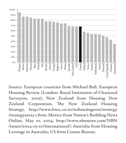
Homeownership is the ultimate American dream and the aspiration of families all over the world. Thanks to the post-war boom, US homeownership rates soared from less than 44 percent in 1940 to 62 percent by 1960. Since then, however, the rate of increase has slowed so that only 7 percent more families own their own homes today.1
Although Americans like to believe they are number one, the figure below shows that many other countries have higher homeownership rates, including Belgium, Britain, Ireland, Italy, Spain, and even Mexico. Due to post-communist privatizations, many Eastern European nations also have significantly higher rates, though many of the homes in these countries are condominiums in Soviet-built apartment buildings.
When 80 percent or more of families in so many other countries own their own homes, why has American homeownership virtually halted in the high 60s? One important reason is the increasing number of states, regions, and communities that have adopted so-called smart growth or some other form of growth-management planning. Advocates claim that such planning improves urban livability, but such claims are questionable. The main effect of smart growth and other growth-management planning is to dramatically increase housing prices and reduce housing affordability.
Economist Paul Krugman divides the country into what he calls the “Zoned Zone,” where “land-use restrictions” make “it hard to build new houses,” and what he calls “Flatland,” where housing prices have not increased much faster than inflation. Krugman observes that prices are rapidly increasing in the Zoned Zone but remain very affordable in Flatland.2
Krugman’s colorful terms are a bit misleading because most of the cities in Flatland have zoning. By itself, zoning does not make housing unaffordable; it is only when it is made a part of growth-management planning that housing prices start skyrocketing. But Krugman is correct in his division of the country. What he calls the Zoned Zone includes the Pacific Coast states, the New England–Washington, DC corridor, Florida, and a few metropolitan areas such as Denver and Minneapolis-St. Paul. What Krugman calls Flatland includes much of the South other than Florida, much of the Midwest other than Chicago, the Twin Cities, and a few smaller cities, and most of the Rocky Mountain regionother than Arizona, the Denver-Fort Collins area, and a few smaller cities.
Today, a family in an American city without growth-management planning can buy a very nice “middle-manager’s” home, with about 2,200 square feet, four bedrooms, two-and-one-half baths, and a two-car garage, for $150,000 to $200,000. In cities that have had growth-management planning for ten to fifteen years, that same home costs $300,000 to $400,000. In cities that have had it for twenty-five years or more, the same house costs from $500,000 to as much as $1.5 million.3 This additional cost is the growth-management planning penalty imposed on people who move to or buy their first home in these communities.
Previous researchers have shown that land-use regulation has increased housing prices in many parts of the United States. “Government regulation is responsible for high housing costs where they exist,” say Harvard economist Edward Glaeser and Wharton economist Joseph Gyourko. In particular, they add, “difficult zoning seems to be ubiquitous in high-cost areas.”4 Other researchers have found that rapid growth in housing prices is strongly “correlated with restrictive growth management policies and limitations on land availability.”5
This paper will compare the timing of planning rules with housing price trends and show that prices usually start to rise very soon after such rules are imposed. The paper will also estimate the actual planning penalty in the metropolitan areas that have imposed some form of growth-management planning.
The Benefits of Homeownership
There are several reasons why America should worry about affordable homeownership. Because a home is the most valuable asset many families will ever own, homeownership rates are an indicator of the wealth of a society. More important, however, homeownership also contributes to that wealth in several ways.
First, people can use the equity in their homes to start small businesses. Most American small businesses get at least part of their initial capital this way, and America’s high rate of small-business formation is partly due to the ease with which homeowners can borrow against their equity. Peruvian economist Hernando De Soto traces the poverty of many developing nations to the difficulty residents of those nations have in acquiring title to their homes and borrowing against those homes to start small businesses.6
Second, homeownership provides many benefits for children, and those benefits are most pronounced for children of lower-income families. Children in owner-occupied homes are less likely to drop out of school.7 After adjusting for income and other factors, such children score 7 to 9 percent higher on standardized math and reading exams.8 The effect is so pronounced that some economists have suggested that we can improve educational outcomes more cost effectively by promoting homeownership than by spending more on the schools themselves.9
One reason children in owner-occupied homes may do better is that ownership gives people incentives to take better care of their dwellings. This means people who own their own homes tend to live better than those who rent. The opportunity to own a home and the need for a down payment encourages people to save money—which is good for the economy—and the tendency to save more money seems to continue after the home is purchased. Homeownership also leads to measurable increases in self-esteem and neighborhood stability, which probably contributes to the better educational outcomes.10
Whether they know these facts or not, Americans have a deep faith in the value of homeownership. Any politician advocating a reduction of homeownership would not be likely to win an election. Yet any politician who supports growth-managing planning is promoting huge barriers to homeownership.
Growth-Management Planning
As practiced today, growth-management planning usually means smart growth, which refers to a set of planning policies aimed at limiting the spread of urbanization and increasing the density of existing developments, supposedly without reducing actual growth rates. Not all growth-management planning is smart growth, however: Many of the American cities that originally enacted growth-management policies hoped to slow growth and keep densities low. Because planners tend to follow fads, many of those early plans have morphed into smart-growth plans. But whatever the goal, any policy that attempts to slow growth, direct growth to certain areas, or manipulate densities is likely to reduce housing affordability.
All of the following planning policies can restrict the supply of homes and drive up housing prices:
- Urban growth boundaries, urban service boundaries, large-lot rural zoning, or other restrictions on the amount of land available for development;
- Purchases of greenbelts and other open spaces that reduce the amount of land available for development;
- Design codes requiring developers to use higher-cost construction methods or designs;11
- Historic preservation ordinances, tree ordinances, and other rules restricting or increasing the cost of development;
- Impact fees aimed at discouraging development;
- Growth caps limiting the number of permits that can be issued each year;
- Concurrency rules requiring adequate financing for all urban services before building permits can be issued;
- Lengthy permitting processes that force developers to hold land for several years before they are allowed to develop it;
- Planning processes that allow people to easily appeal and delay projects, creating uncertainty about when a project can begin;
- Inclusionary zoning programs requiring developers to subsidize some housing for low-income people, effectively increasing the price of the remaining housing.
One subtle yet significant way in which these sorts of rules contribute to unaffordable housing is by reducing competition in the homebuilding industry. Portland homebuilders, for example, admit that the urban growth boundary “has given them a competitive advantage by making land acquisition here too difficult and costly for national developers.”12
Few cities or regions have adopted just one of these policies, and the combined effect of several such policies can lead to extremely unaffordable housing. Studies which conclude, for example, that urban growth boundaries have by themselves not driven up housing costs can be misleading if they compare a city that has urban growth boundaries with another city that has no boundaries but has adopted other policies such as large-lot rural zoning or onerous permitting processes.
As will be described in greater detail in the discussion section of this paper, growth-management planning began in the United States around 1970, when Boulder, Colorado and suburbs of New York City and San Francisco began experimenting with limits on building permits and urban growth boundaries. Despite the fact that housing affordability rapidly declined in these regions, growth management grew in popularity.
Some planning mandates came from state legislatures, as when Oregon required all cities in the state to draw urban growth boundaries by 1980 or Florida required all of its cities to write growth-management plans by 1992. In other places, such as Denver and the Twin Cities, regional governments imposed urban service boundaries. In still other places, such as the Boston area and most of California, growth-management planning was strictly by local governments, sometimes responding to tax policies that penalized residential development.
Methods
The goals of this paper are to:
- Compare the growth in metropolitan area housing prices with the enactment of growth-management plans to see if there is any correlation between the two;
- Estimate the additional cost imposed on homebuyers by growth-management plans in each metropolitan area.
Data Sources
The paper will measure housing affordability using data from several sources.
- Changes in housing prices over time in more than three hundred metropolitan areas come from the Department of Commerce’s Office of Federal Housing Enterprise Oversight (OFHEO) home price index.13 This index is based on repeated sales of the same homes, so it is not influenced by changes in average size or quality over time. The index goes back as far as 1975 for some metropolitan areas, but in others—especially smaller regions—it may not begin until much later.
- Median family incomes and median home prices in each of several hundred metropolitan areas from 1959 through 1999 are from the decennial census.14 Dividing the median value by the median income produces the value-to-income ratio, a rough index of housing affordability. In any given year, housing markets with lower value-to-income ratios are more affordable than those with higher ratios.
- Median family incomes for 2005 are from Department of Housing and Urban Development estimates.15
- Median home values for 2005 are calculated by updating the 1999 values using OFHEO’s home price index.
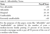
- In addition to the value-to-income ratio, housing affordability depends on interest rates. Using historic mortgage rates by the Federal Housing Finance Board, this paper calculates the number of years it would take a median-income family to repay the mortgage for 90 percent of the cost of a median-value home if the family devotes 25, 33, or 40 percent of its income to the mortgage.16 Lenders typically expect buyers to apply no more than 25 percent of their incomes to a mortgage, and a home loan normally lasts no more than thirty years. Using this measure, a market where it would take longer than thirty years go pay for a home would have to be considered unaffordable. For the purposes of this paper, terms such as “affordable” and “unaffordable” are defined as shown in table 1.
- The number of owner-occupied homes and the aggregate value of those homes in each metropolitan area in 1999 is from the 2000 census.17 Census Bureau population estimates for 2004 are used to estimate the change in the number of owner-occupied homes in 2005.
- Some regions’ median-value homes may be larger or higher in quality than in others. An alternative view is provided by Coldwell Banker, which compares the price of similar homes in different markets in its annual survey of the cost of a standardized four-bedroom, two-and-one-half-bath, 2,200-square-foot home “in a neighborhood that is typical for corporate middle managers.”18 Since Coldwell Banker’s prices are for cities, not metropolitan areas, they may not be exactly representative of each metropolitan area in this report, but they do provide a different perspective.
- All dollar figures before 2005 are adjusted for inflation to 2005 dollars using the gross-domestic product price deflator.19
United States Housing Trends
For the sake of reference, we start by looking at housing affordability the United States as a whole. The US Home Price Index figure below shows the home price index published by the Office of Federal Housing Enterprise Oversight adjusted for inflation.20 The index has been placed in the figure so that 1999 equals the median home value reported by the Census Bureau in that year. The graph thus shows a rough estimate of the price over time of a 1999 median home in thousands of 2005 dollars. This paper includes similar figures for various metropolitan areas.
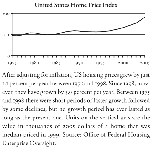
The figure shows that the housing market drastically changed in about 1998. Between 1975 and 1998, US home prices grew by only about 1 percent per year faster than inflation. Since then prices have grown by nearly 6 percent per year. A closer look reveals short periods of relatively fast growth, such as 1977 through 1979 and 1986 through 1989, followed by “correctional” periods in which prices fell. This suggests that the recent rapid growth is likely to be followed by a period of decline. No growth period between 1975 and 1995 lasted longer than six years; the current growth period has lasted eleven.
The rapid growth in housing prices since 1998 began when crashes in the dot-com and telecommunications industries led many people to conclude that it was safer to invest in real estate than in the stock market. In areas with little growth-management planning, this led to modest price increases and homebuilders responded by building new homes. But in areas with growth-management planning, homebuilders had a difficult time responding, so prices increased rapidly—even, in some cases, in regions that were suffering a downtown. In regions with growth-management planning, prices grew by 4 to 15 percent per year, while regions without growth-management planning saw prices grow only about 1 to 3 percent per year. Sadly, this meant that since 1999, the regions whose housing was already the least affordable saw the greatest declines in affordability.
Table 2 shows median-family incomes and median-home values for the United States in census years as well as in 2005. The table also shows several measures of housing affordability that can be calculated from these data:
- The value-to-income ratios for the US as a whole and the median ratios for metropolitan statistical areas (MSAs);
- The payoff period for a family devoting 25 percent of its income to a mortgage; and
- For comparison, the payoff period for a family devoting 40 percent of its income to a mortgage.
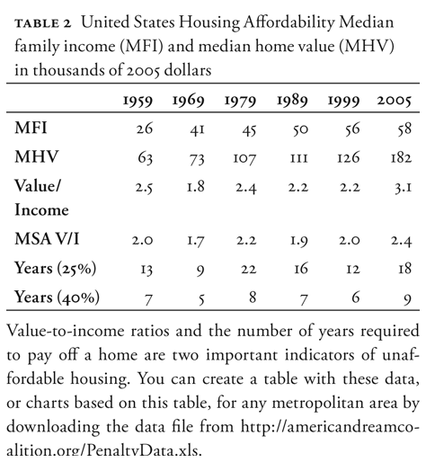
The table shows that, before 2005, value-to-income ratios hovered closely around 2.3. The median metropolitan area value-to-income ratios were slightly lower than the national average and hovered even more closely around 2.0. Both were pushed up after 1999 by a combination of increased real estate investments and the extremely high housing prices in markets with growth-management planning.
High interest rates pushed housing into the marginal range in 1979. Otherwise housing has been affordable, though it is heading back to the marginal range despite low interest rates in 2005.
The appendix of this paper lists value-to-income ratios from 1959 to 2005 for each metro area, along with the annual growth rate in housing prices from 1999 through 2005, median home value in 2005, Coldwell Banker home value, planning penalty, percent overpricing, and aggregate penalty for all homes in each metro area. Readers can download an Excel spreadsheet from http://www.americandreamcoalition.org/PenaltyData.xls that contains the rest of the raw and calculated data used in this report, and which allows easy creation of several useful tables and charts for any of more than three hundred metropolitan areas.
The Planning Penalty
Based on the median-home values and value-to-income ratios, this paper will calculate four different numbers for each metropolitan area:
- Percent overpricing, that is, the percentage by which housing in a metro area is overpriced relative to the median metro area;
- The planning penalty, which is the cost of a median-value home that can be attributed to housing shortages caused by planning or some other unusual factor;
- The total penalty, which is the total amount by which all owner-occupied homes in a region are overpriced due to planning-induced housing shortages;
- The total annual penalty, which is the annual cost to homebuyers of planning-induced housing shortages.
Percent Overpricing
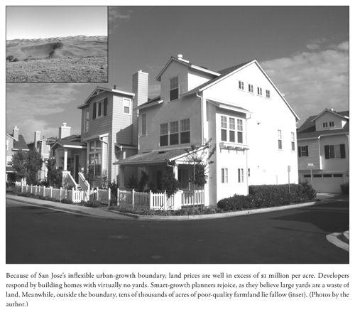
In the absence of restrictions on housing supply, housing prices in any metropolitan area will tend to be proportional to incomes in that area, mainly because people with higher incomes will buy larger homes. Housing in San Jose, with a 2005 median family income of $105,000 per year, will naturally cost more than in McAllen, Texas, whose median family income was less than $30,000 per year. But it should not cost fourteen times as much for a home that is just 20 percent larger, as it did in 2005.21
For census years (1959–1999), this paper uses the median value-to-income ratio for metropolitan areas in those years as a standard value-to-income ratio against which each metro area can be compared. In 1959, 1989, and 1999, this ratio was very close to 2.0, though it was a little lower in 1969 and a little higher in 1979. Metropolitan areas with standard ratios had affordable to very affordable housing, even in 1979 when interest rates were high.
As used in this paper, percent overpriced for 1959 through 1999 refers to the share of the value of a home that is higher than it would be if the value-to-income ratios were equal to this standard. For example, if median family incomes are $50,000 in 1999, when the standard ratio was 2.0, then median homes should cost about $100,000. If some form of housing shortage pushes the cost to $150,000, then the market is 33 percent (not 50 percent) overpriced. This makes it easy to calculate that, say, a $225,000 home in that market is overpriced by $75,000.
To be fair, not all causes of housing shortages will have the same proportionate effect on all homes. A $25,000-per-home impact fee, for example, will have smaller percentage increase on expensive homes than on inexpensive ones. Inflated land prices caused by an artificial or natural land shortage will affect home prices proportional to lot sizes, not necessarily to home values. So the overpricing percentages must be used with care depending on the urban area.
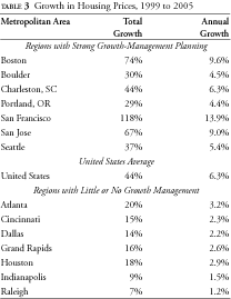
By 2005, the median metro area value-to-income ratio had increased to 2.4. This was partly due to rapidly growing prices in the increasing number of regions with growth-management plans. As the examples in table 3 suggest, regions with such plans saw prices grow by 4 to 14 percent, while regions without such plans saw prices grow by 1 to 3 percent. If this lower rate of growth is due to the new money coming into the real estate market, then any excess growth is due to restrictions on housing supply.
For the 2005 standard value-to-income ratio, this paper will use 2.24, which is what the ratio would have been if 1999 median-home values had grown by 2.5 percent per year. Any markets with higher ratios in 2005 will be considered overpriced.
The Planning Penalty
Not all overpricing is due to growth management. By definition, at any given time, half of all regions will be priced at more than the median value-to-income ratio and half less. Table 4 shows that variations tended to be small in 1959, but dramatically increased over the next three decades as more communities adopted growth-management plans.
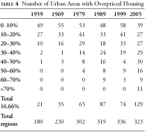
Judging from changes over time in individual metropolitan areas, variations of up to plus or minus 20 percent from the median can occur due to natural differences in local economies and their economic cycles. However, sustained variations greater than 20 percent appear mainly due to some factor causing a housing shortage, most often a growth-management plan.
In regions that have growth-management planning, this paper will use the term planning penalty to mean the additional cost of a median-value home that is more than 20 percent greater than median family incomes multiplied by the standard value-to-income ratio. For example, say the 2005 median-family income in a particular metro area is $44,640. Multiplying this by the standard value-to-income ratio of 2.24 yields $100,000. If prices can vary up to 20 percent for reasons other than planning, then the highest price the area could have without planning would be $120,000, which is about 2.69 times median-family incomes. The planning penalty is equal to any price above that.
At $850,000 per median-value home, the San Francisco metropolitan area, where the value-to-income ratio is 11.6, had the highest planning penalty in 2005. San Francisco is 81 percent overpriced, meaning more than 80 percent of the cost of San Francisco homes is due to housing shortages, almost entirely caused by growth-management planning. Because $120,000 is 16.67 percent more than $100,000, this formula results in a positive planning penalty for any region that is overpriced by more than 16.67 percent.
The planning penalties calculated using this formula are conservative in two significant ways. First, the 2.24 value-to-income ratio is probably higher than it should be because it is based on a 2.5-percent annual price appreciation since 1999, but the average price appreciation for metro areas without growth-management planning was closer to 2.0 percent. Second, the assumption that the first 20 percent above this 2.24 value may be due to factors other than planning is generous. Because of these cautious measures, it is likely that the actual planning penalties are, on average, at least 25 percent greater than the penalties stated in this report.
The results will be particularly conservative in metro areas that were very affordable in 1999 but whose affordability declined since then. Housing in Tallahassee, Florida, for example, was far more affordable than average in 1999. Because of a recent growth-management plan, housing prices have grown by 6 percent per year and affordability has dramatically declined in the past six years. But it has not yet declined enough to register using this formula. If housing prices had grown by just 2.5 percent per year, the median-value home would cost $30,000 less, which is probably the true planning penalty for the region. This alternative calculation of a planning penalty applies mainly to Florida, Minnesota, Wisconsin, and a few regions in the Boston–Washington, DC corridor.
Growth-management planning is not the only possible cause of a severe housing shortage. Another cause could be a shortage of land because most land is government-owned or otherwise unavailable for development. Such situations will be described in a special section on land-ownership penalties below. In most cases, however, regions with severely overpriced housing can trace shortages to growth-management planning and it is appropriate to refer to the extra cost of housing in these regions as planning penalties.
As previously noted, readers can download a spreadsheet providing affordability data for more than three hundred metropolitan areas from http://www.americandreamcoalition.org/PenaltyData.xls. This spreadsheet allows readers to quickly calculate the planning penalty and graph historic housing prices and affordability measures in most of those metropolitan areas.
The Total Penalty
The planning penalty is the cost of planning to the purchaser of a median-priced home. In contrast, the total penalty is the total cost that planning imposes on all owner-occupied housing in an entire region, state, or nation. The total annual penalty is the total added amount homebuyers are forced to pay each year due to such planning.
The total penalty can be calculated from census data. The 2000 census estimated that the value of all owner-occupied housing in the nation was about $12.0 trillion. Since then, the population has increased by about 5 percent, and so presumably has the number of owner-occupied homes, while the average value of those homes has increased by 44 percent. This indicates that owner-occupied housing today is worth about $18.0 trillion.
We can calculate the total 2005 value of homes in each metro area assuming the number of owner-occupied homes in each metropolitan area grew at the same rate as the population and that the average value of those homes grew at the rate of the home price index published by the Department of Commerce. Assuming that the overpricing percentages for median-value homes apply to all homes in each metro area, and leaving out the overpricing of land-short metro areas such as Honolulu, the total planning penalty for the 120 metro areas with such penalties is close to $5.5 trillion, or slightly more than 30 percent of the total value of US owner-occupied housing.
Los Angeles has the largest total penalty at nearly $700 billion. New York is close to $500 billion, and twelve more regions, nearly all of which are in California or the Boston–Washington, DC corridor, have total penalties of more than $100 billion. Note that this does not include any costs to renters or to purchasers of retail, commercial, or industrial land.
During the 1990s slightly more than 5 percent of America’s housing stock was sold each year. If the average American home is resold or replaced about every twenty years, the annual cost of growth-management planning to homebuyers is nearly $275 billion. While part of this cost is offset by the gains to home sellers, the discussion section of this paper will show that both the losses and the number of losers exceed the gains and the number of winners.
Region-by-Region Review
California
Planners sometimes lament that California, unlike Oregon, has no state growth-management law or strong regional governments. Instead, the plans are written by individual cities and counties that are often in conflict or competition with one another. Still, several features have unified California cities to create some of the least affordable housing markets in the world.
First, California state law does require that planners allow broad citizen participation in planning and development decisions. This includes an appeals process that people can use to challenge proposed developments that they do not like. As described in Bernard Frieden’s 1979 book, The Environmental Protection Hustle, such appeals were so easy that, in one case, “a lone Boy Scout doing an ecology project was able to bring construction to a halt on a two hundred–unit condominium project.”22 Since homeowners are more likely to challenge high-density developments with affordable housing, fearing that such housing will “bring down the neighborhood,” homebuilders ended up building mostly low-density, high-cost housing.
Second, citizens of many cities have used the democratic process to impose strict growth limits on their cities. Even if a city council were interested in promoting growth, people often use initiative petitions or other means to limit that growth. For example, in 1999 voters in San Ramon approved a two-year moratorium on any changes in the city’s comprehensive plan, while voters in Half Moon Bay approved a measure limiting residential growth to 1 percent per year.23
As if that were not enough, in 1978 California voters approved Proposition 13, which greatly limited the revenues local governments could get from property taxes on homes. Instead, cities and counties became dependent on retail sales tax revenues. Cities responded by adopting beggar-thy-neighbor policies, providing tax breaks to attract retailers while zoning for low densities to force other cities to accept new residents.
The result of these pressures has been the opposite of smart growth’s demand for density and compact cities. Instead, the push from both homeowners and tax policy was to keep densities low. Some cities went so far as to allow no new developments, even as small as a few homes, without a vote of the people. Meanwhile, many counties prevented much development outside the cities.
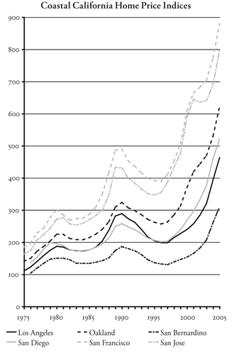
The result is that California housing affordability problems began in the early- to mid-1970s. While San Francisco, San Jose, Los Angeles, and San Diego housing markets were less affordable than other US regions in 1969, they were still affordable—that is, a median-income family could buy a median-priced home in less than fifteen years and value-to-income ratios were around 2.2—not significantly different from the national average in the 1990s. But by 1979, the value-to-income ratios in these regions increased to four or more, increasing again to five or more by 1989, six or more by 1999, and nine or more by 2005.
Ironically, the “farmland” being protected by the coastal cities’ planning efforts is for the most part marginal, usually not good for much more than livestock range. California’s real farm base is in the Central Valley, but most cities in the Central Valley, with the exceptions of Sacramento and Davis, have imposed far fewer planning rules than coastal cities. So Fresno, Modesto, Stockton, and other Central Valley cities remain more affordable than their coastal counterparts. Nor is urbanization much of a threat to California’s vast open spaces. The USDA says that less than 5.4 percent of California was developed in 1997.24 According to the 2000 census, 94.4 percent of the people in America’s most populous state live on just 4.2 percent of its land area.25
The total planning penalty for all California metropolitan areas is $2.7 trillion, or nearly half of the nationwide penalty. Nearly $2.5 trillion of this is in coastal metro areas, while $235 billion is in central valley regions.
San Francisco-Oakland Bay Area
San Francisco planning penalty: $850,000
Oakland planning penalty: $400,000
The San Francisco Bay Area has been the nation’s least affordable major housing market since at least 1989. Yet as recently as 1969, Bay Area housing was quite affordable. Value-to-income ratios were no greater than the nationwide average ratio in 1999, and a median-income family could spend 25 percent of its income to pay for a median-priced house in less than fifteen years.
Since then, Bay Area governments have done everything possible to drive up home prices. Alameda, Contra Costa, Napa, San Mateo, and Sonoma counties all have growth boundaries.26 While Marin County does not, virtually every city in Marin County has a growth boundary.
On top of this, Bay Area counties have purchased large areas for regional parks. By 1984, David Dowell’s book, Suburban Squeeze, reported that more than 15 percent of the region’s land was in such parks.27 Today, parks and preserves in the five-county San Francisco-Oakland area total nearly 550,000 acres, not counting areas outside of urban growth boundaries that are protected by restrictive zoning.28 By comparison, the 2000 census found that the urbanized land in these counties (including parks in those urban areas) totaled only 502,000 acres.
The result was a dramatic decline in affordability in the 1970s. By 1979, a median-income family dedicating 40 percent of its income to a mortgage would not be able to make the interest payments on a median-priced home. Both the 1990 and 2000 censuses found that the Bay Area was the least affordable housing market of any urban area in the nation. Despite this unaffordability, Bay Area housing prices grew by an incredible 14 percent per year between 1999 and 2005.
The total planning penalty for the San Francisco and Oakland metropolitan areas is $591 billion. San Francisco (which includes Marin, San Francisco, and San Mateo counties), accounts for $331 billion of this, while Oakland (which includes Alameda and Contra Costa counties) accounts for the rest.
Coldwell Banker says that a 2,200-square-foot home that would cost $152,000 in Houston in 2005 would cost $836,000 in Walnut Creek (Contra Costa County), $859,000 in San Mateo (Marin County), $1.10 million in Oakland (Alameda County), $1.30 million in San Francisco, $1.33 million in San Mateo, and $1.55 million in Palo Alto (both in San Mateo County).
San Jose
San Jose planning penalty: $513,000
In the 1950s and 1960s, San Jose may have been the fastest-growing urban area in America, more than quadrupling from 95,000 people in 1950 to 445,000 in 1970. Despite this growth, San Jose housing was still affordable in 1969. But fears of “Los Angelization” led San Jose and Santa Clara County to impose an urban growth boundary and other planning restrictions in 1974. Planners promised to expand the boundary when financing of needed urban services was assured. But such expansion never took place, partly because Proposition 13 in 1978 reduced the stability of urban finances and partly because sprawl opponents lobbied heavily to prevent any expansions.
Between 1974 and 1979, housing prices grew by at least 50 percent. While San Jose incomes remained about 30 percent more than the national average, by 1979 San Jose’s homes were 128 percent more expensive than the rest of the country. Prices continued to grow for another decade, then crashed as defense industries contracted with the end of the cold war. This made housing slightly more affordable in 1999, when a median-income family devoting a third of its income could pay off a median-priced home in a mere 81 years.
Since 1999, San Jose’s economy has again crashed, but its housing market continued to bubble as interest-only loans, 40-year mortgages, and other risky financing allowed speculators to bid up homes. Between 2001 and 2004, San Jose lost 17 percent of its jobs and office vacancy rates soared from 3 to 30 percent. Yet housing prices grew by 13 percent in those years and somehow managed to grow another 18 percent in 2005. With two-thirds of current housing prices attributable to the planning penalty, compared with only 58 percent in 1989, prices appear poised for a greater fall than the one in the early 1990s.
According to Coldwell Banker, someone selling a house for $152,000 in Houston would have to pay an incredible $1.27 million to get a similar home in San Jose. San Jose’s total planning penalty was more than $200 billion in 2005.
Such high prices have had major effects on the region. First, growth has slowed to a trickle. The San Jose metro area grew by a mere 1.2 percent per year in the 1990s, and it actually lost population between 2000 and 2004. This slow growth is largely because many Silicon Valley companies now locate their factories and offices in other regions where their employees can afford housing.
People still work in San Jose even though few who do not already own homes can afford to buy a house there. Many live in apartments or condominiums, which no doubt pleases the smart-growth planners who are guiding San Jose’s future. But many others commute from outside the region, some driving eighty miles each way from Stockton, where housing remains affordable. Such long commutes, of course, are just what smart growth is trying to avoid. Ironically, the farmlands around Stockton are far more productive for agriculture than the grassy rangelands that San Jose is protecting from development with its urban growth boundary.
Los Angeles
Los Angeles planning penalty: $316,000
Orange County planning penalty: $387,000
Riverside-San Bernardino planning penalty: $160,000
Ventura planning penalty: $345,000
Supposedly the epitome of sprawl, the Los Angeles urban area is actually the densest urban area in America. The 2000 census found more than 7,000 people per square mile compared with a mere 5,400 in the New York urban area. While the city of Los Angeles itself is not at dense as New York (26,400 per square mile), San Francisco (16,600), or Chicago (12,750), it is still far denser, at 7,900 people per square mile, than almost any other major city in America.
Los Angeles differs from New York, San Francisco, and Chicago in that its suburbs also have high densities, whereas the other denser cities have sprawling low-density suburbs. Los Angeles suburbs such as Cudahy, Huntington, Lenox, and Maywood all have more than 20,000 people per square mile. While those are exceptional, the Los Angeles urban area has a relatively flat density gradient, while New York and San Francisco show sharp declines from the city centers outwards.
As Robert Bruegmann points out in his recent book, Sprawl: A Compact History, the thing that makes Los Angeles special is water, or rather the lack of it.29 The city of Los Angeles famously managed to get a steady source of water from the Owens Valley, in eastern California. But landowners in areas that do not have a sufficient water supply simply cannot develop their land. Since much of the land around Los Angeles is essentially desert, development has been restricted to Los Angeles and other cities that have a water supply. Los Angeles also faced other barriers to expansion in the form of the federally owned Angeles and Cleveland national forests.
The results were similar to those in San Jose and San Francisco. As the center of defense contracting, Los Angeles suffered more than the northern cities from the post-cold-war decline in defense spending, with home prices falling by more than 20 percent between 1990 and 1995 and not recovering to 1990 levels until 2000.
Today, Los Angeles’ planning penalty totals to $697 billion. The total penalties in nearby Orange, Riverside, San Bernardino, and Ventura counties amount to another $498 billion.
Coldwell Banker says that the $152,000 Houston home would cost anywhere from $788,000 in Pasadena up to nearly $1.9 million in the Orange County suburb of La Jolla, the highest-priced housing market considered by the realty company’s study.
Central Valley
Bakersfield planning penalty: $69,000
Davis planning penalty: $234,000
Fresno planning penalty: $118,000
Sacramento planning penalty: $204,000
California’s Central Valley produces one-third of the nation’s food. It is also the home of well over three million people who live in cities that are growing much faster than those on the coast, mainly because coastal cities are so unaffordable.
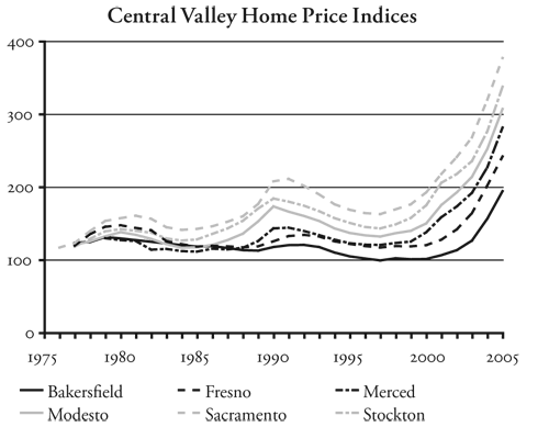
These metro areas have fewer restrictions than those on the coast. Yet they still have planning penalties totaling $235 billion. The Sacramento and Davis areas have 40 percent of the housing in Central Valley metro areas but account for more than half the penalties.
San Diego
San Diego planning penalty: $351,000
San Diego’s regional government, the San Diego Association of Governments (San-DAG), has played a greater role in growth-management planning than most other California regional governments. While local governments did some growth-management planning in the 1970s, in 1980 SanDAG adopted a plan that promoted high-density infill in San Diego and discouraged growth in the suburbs using large-lot zoning and impact fees. This plan created a two-class urban structure, as only the wealthy could afford the suburbs while low-income people faced declining urban services in the core as infill developments overwhelmed the existing infrastructure.30 SanDAG continues to promote compact development, particularly along transit corridors.
San Diego’s total 2005 planning penalty was more than $250 billion. Mortgage insurer PMI ranks San Diego as the region most likely to suffer a decline in housing prices in the next two years, closely followed by several other California regions and regions in the Boston-New York corridor.31
Northeast
Agricultural reserves (which usually involve purchases of easements), low-density zoning, and lengthy permitting and regulatory processes are the most common growth-management tools used in the Northeastern United States, which here is defined to range from New England to Washington, DC. All of these rules have made much of this region the second-most expensive housing market in the country after California.
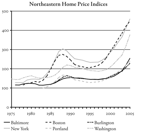
New York and Boston vie for being the most expensive major urban areas, with Washington lagging behind and other cities such as Baltimore, Maryland, Burlington, Vermont, and Portland, Maine well behind. But all appear to be trying to catch up to New York and Boston. Smart growth or other growth-management planning has been strongly promoted by the governors of Maine, Maryland, and New Jersey.
Boston
Boston planning penalty: $225,000
Lawrence planning penalty: $112,000
Portsmouth planning penalty: $83,000
Worcester planning penalty: $83,000
Not only was Boston housing affordable in 1969, it continued to be marginally affordable in 1979 despite high interest rates. The value-per-income ratio in 1979 was less than 2.5, well under the ratios found in California cities in that year. Yet by 1989, Boston’s value-to-income ratio shot up to 3.8, making housing extremely unaffordable even with lower interest rates.
According to Edward Glaeser, a Harvard economist specializing in urban issues, Boston’s affordability declined because cities in the region passed numerous regulations that stifled home construction. Glaeser and two graduate students examined the planning rules of 187 communities in the Greater Boston region, which includes Essex County (Lawrence) and Cambridge-Newton. He found:
- Fifty-four communities have growth caps or similar rules limiting the number of homes that can be built each year;
- At least thirty-six communities have large minimum lot sizes, in some cases requiring that lots be no smaller than 1.6 acres. Most of these also prohibit irregularly shaped lots (so-called flag lots) that would make it possible to fit more lots in a given area;
- More than two thirds of the communities have wetland rules that are stricter than state or federal laws and rules.32
These and other rules have had a clear effect on homebuilders’ abilities to meet the demand for housing. In the 1960s, says Glaeser, cities in the Boston metropolitan area issued permits for 172,459 new homes. Despite much higher housing prices, this declined to 141,347 in the 1980s and to just 84,105 in the 1990s.33
Glaeser estimates that the scarcity created by these rules boosted median housing prices in the Greater Boston metropolitan area (which includes eleven of the metropolitan areas rated in this paper) by an average of $156,000.34 This is fairly close to the housing penalties calculated for those metro areas in this paper: when weighted by the number of owner-occupied homes in those areas, the penalty averages $171,000. The total penalty for the Greater Boston metro area is nearly $300 billion.
In 1989, Boston homes were overpriced by 41 percent, and the housing crash that followed led to a 25 percent decline. By 2005 homes were overpriced by 52 percent, so an even larger decline is likely. Mortgage insurer PMI ranks Boston as the region third most likely to suffer a decline in housing prices in the next two years, preceded by two California regions.35
New York
New York planning penalty: $312,000
Newark, New Jersey planning penalty: $155,000
Bridgeport, Connecticut planning penalty: $119,000
Stamford, Connecticut planning penalty: $465,000
The greater New York metropolitan area has pioneered a variety of urban planning efforts. In 1919, New York City became the first city to pass a zoning ordinance. Suburbs of New York wrote many of the early “master plans” once favored by urban planners; Stamford, Connecticut, for example, wrote its first master plan in 1929. The New York Regional Planning Association has long promoted planning by the various regional and local governments. Ramapo, New York, was the first city to pass a slow-growth ordinance, in 1970.
New York City’s housing market has been distorted by rent controls of one form or another since 1943.36 These controls have contributed to a major housing shortage in the city because it makes the construction of new housing especially risky.
Although Stamford was the nation’s second-least affordable housing market in 1959, housing in New York City itself, though priced somewhat higher than the rest of the country, was still affordable as late as 1969. By 1989, however, New York City housing was about 60 percent overpriced, while housing in the Greater New York metro area was 46 percent overpriced. Prices dropped by 23 percent in the deflation that followed, but fully recovered by 2001 and as of 2005 have grown by another 49 percent.
The total planning penalty for the New York metro area (which includes New York City plus Putnam, Rockland, and Westchester counties) is more than $480 billion. The penalty for the Greater New York metro area, which extends from New Haven to Newburgh and from Poughkeepsie to Ocean City, is more than $1.1 trillion.
Washington, DC
Washington, DC planning penalty: $135,000
Baltimore planning penalty: $59,000
Washington housing prices have followed the same roller-coaster ride as Boston’s and New York’s, although the peaks and troughs have not been as great. Outside of the District of Columbia, Maryland is the home of smart growth, in the sense that the term was first used by Maryland Governor Parris Glendenning to refer to policies promoting compact urban development. Glendenning encouraged counties to create agricultural reserves and restrict growth to already-urbanized areas. This led to overpriced housing in Baltimore and even distant Hagerstown.
Just north of DC, Montgomery County, Maryland has protected well over 40 percent of the county from development through easements or tradable development rights. East of DC, Prince George’s County has protected well over a third of its land through rural zoning or parks.
The total planning penalty for the Washington, DC, metro area is $218 billion. The penalty for the adjacent Baltimore metro area is another $49 billion.
Maine–New Hampshire–Vermont
Portland, Maine planning penalty: $64,000
Burlington, Vermont planning penalty: $42,000
Manchester, New Hampshire planning penalty: $58,000
Lewiston, Maine planning penalty: $7,000
Nashua, New Hampshire planning penalty: $59,000
Portsmouth, New Hampshire planning penalty: $84,000
Maine passed a planning law in 1991 encouraging, but not requiring, cities to do growth management. As of 1997, Maine was the least developed state in the East, with 96.6 percent of the state being rural open space.37 Despite this, in 1999 the state’s governor began aggressively promoting a “war on sprawl,” encouraging communities to write growth-management ordinances. The result has been a 50 percent or greater increase in housing prices in Portland and certain other Maine cities since 1999, though Bangor has so far avoided the problem. The total penalty in Portland and Lewiston is close to $5.5 billion.
Vermont passed a comprehensive planning law known as Act 250 in 1970 and a growth-management planning law in 1988. Burlington, the state’s only metro area, started having affordability problems in the 1980s. Burlington’s total planning penalty is just over $2 billion.
Defying the state motto of “Live Free or Die,” New Hampshire passed smart-growth legislation in 2000 encouraging cities to write plans to control sprawl and conserve rural areas. Housing had been affordable in the state through 1999, but in the following six years housing prices grew by 70 percent. In that short time the total penalty for New Hampshire’s three metro areas has increased to more than $13 billion.
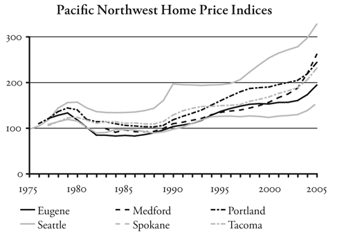
Pacific Northwest
Oregon
Portland planning penalty: $60,000
Eugene planning penalty: $48,000
Medford planning penalty: $121,000
Rules written under Oregon’s 1971 planning law required all Oregon cities to draw urban growth boundaries, and most did so by 1980. However, the state suffered a major recession in the early 1980s—the population even declined in 1982 and 1983—so the boundaries did not have a big impact on development or housing prices until around 1990.
Homebuilders sought to expand the boundary when land prices in the Portland area started to rise in 1990, but planners decided instead to rezone neighborhoods inside the boundary to higher densities. When builders said there was little market for high-density developments, Portland and its suburbs offered millions of dollars in tax breaks and other subsidies. This produced a boom in multifamily construction, so owners of existing apartments found their rents flat or dropping even as housing prices doubled in just a few years.
The need for urban growth boundaries seems absurd in a state that is more than 98 percent open space.38 The full absurdity was revealed by a study commissioned by the Willamette Valley Livability Forum, a government-funded organization advocating growth-management planning. Oregon’s Willamette Valley occupies just one-seventh of the state but houses two-thirds of the state’s population. It also has the state’s most productive farmland, and planning advocates have used the fear that urbanization would destroy all the farmland to justify Oregon’s planning system.
The Livability Forum’s study found that 5.9 percent of the Willamette Valley had been developed in 1990. The study found that, with an expected 50 percent increase in population by 2050, Oregon’s restrictive planning rules would allow the urbanization of only 0.7 percent more of the valley. But the study also asked what would happen if the rules were repealed and the free market allowed to rule. In that case, the commissioned report concluded, 1.7 percent more of the valley would be urbanized.39 The high housing prices, congestion, and other costs of Oregon’s planning rules would do nothing more than protect 1 percent of the valley from urbanization.
When measured as either value-to-income ratios or mortgage payoff periods, Portland’s affordability declined more than any other urban area in America in the 1990s. Salem and Eugene Oregon had the second- and third-greatest declines in affordability, indicating that Oregon’s planning process was having similar results in many places.
High housing prices slowed Portland’s growth, but Vancouver, Washington, across the Columbia River and out of reach of Portland’s planners, became the fastest-growing part of the Portland-Vancouver urban area. While Portland itself grew by about 21 percent, and most of its suburbs grew by about 40 percent, Vancouver grew by 210 percent in the 1990s. Fifty miles south of Portland, Oregon’s capital, Salem, also grew, overtaking Eugene as Oregon’s second-largest city by 2000.
The 2001 recession led to Portland having the highest unemployment rates in the nation, but housing in Portland and other major Oregon cities remains overpriced. Corvallis was 24 percent overpriced in 1999 but only 20 percent in 2005. Most cities went the other way, however, with the worst being Medford-Ashland. Because it is close to California and has a better climate than most Oregon cities, Medford-Ashland has attracted many wealthy retirees, making it the most overpriced region in Oregon.
In 1969, Portland median incomes and housing prices were both 5 percent greater than Houston’s. But by 1999, housing prices were nearly twice Houston’s even though incomes were only 9 percent greater. In 2005, Coldwell Banker confirmed that the house that would cost $152,000 in Houston would cost $304,000 in Portland, $327,000 in Eugene, and $387,500 in Medford. The total planning penalty for Oregon metropolitan areas is $51 billion, of which Portland accounts for $36 billion.
Washington
Bellingham planning penalty: $103,000
Seattle planning penalty: $133,000
Tacoma planning penalty: $64,000
Washington passed a growth-management law in 1991 requiring all cities and counties in the western portion of the state to do growth-management planning, but made such planning optional for many areas on the east side. But Seattle and King County had been restricting development long before that. So it is not surprising that the Seattle metro area accounts for $100 billion of the state’s total planning penalty of $130 billion.
Tacoma, Olympia, and other western-Washington metro areas were affordable until the late 1990s. Spokane, the Tri-Cities, and other eastern-Washington metro areas remain affordable today.
Colorado
Boulder planning penalty: $117,000
Colorado Springs planning penalty: $30,000
Denver planning penalty: $58,000
The Colorado Front Range presents some sharp contrasts. On one hand there is Boulder, twenty-five miles northwest of Denver, which began practicing growth management in the late 1960s. At the other extreme is Colorado Springs, seventy miles south of Denver, which has much less growth management. In the middle is Denver and its many suburbs, around which the Denver Regional Council of Governments (DRCOG) drew an urban growth boundary in the early 1990s. Boulder is included with Denver in some data sets and is inside DRCOG’s urban growth boundary, but its long history of growth management makes it quite distinctive.
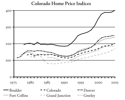
The results can be seen in the Coldwell Banker estimates of the price of a middle-manager’s home: $212,000 in Colorado Springs, $336,000 in Denver, and $546,000 in Boulder. This makes Boulder the most expensive American housing market in Coldwell Banker’s study outside of California, Hawaii, and the Boston-Washington corridor.
Planning penalties in Colorado metro areas total $64 billion. Of this, Denver accounts for $41 billion and the Boulder-Longmont area accounts for another $10 billion.
Florida
Fort Lauderdale planning penalty: $82,000
Jacksonville planning penalty: $8,000
Miami planning penalty: $124,000
Orlando planning penalty: $35,000
Tampa–St. Petersburg planning penalty: $24,000
Like Oregon, Florida passed a statewide land-use planning law in the 1970s that required cities to draw urban growth boundaries. Unlike in Oregon, Florida cities applied this law much more flexibly, freely expanding the boundaries as growth demanded. As a result, housing prices in most Florida regions remained fairly constant between the late 1970s and mid 1990s. Prices in Jacksonville and Tallahassee, for example, grew by less than one-half percent per year from 1978 through 1998, and even Miami prices grew by only 1 percent per year.
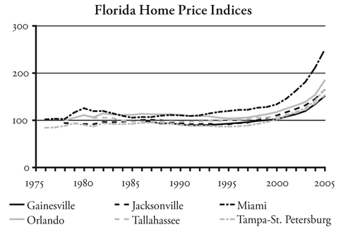
In 1985, however, the Florida legislature passed a growth-management act requiring all cities to write growth-management plans by 1992. Florida also has concurrency requirements allowing cities to deny building permits to developers if the developments would add more traffic than roads can handle. These price increases begin in 1992 in Miami and Fort Myers, 1994 in Gainesville, 1996 in Jacksonville, Sarasota, and Tampa–St. Petersburg, 1997 in Tallahassee, and 1998 in Orlando. These differences reflect differences in local economies and may reflect differences in the timing of the plans in each region. The price increases are significant, averaging 50 to 70 percent in the past seven years and in some cases exceeding 10 percent per year. This has made Miami housing unaffordable and pushed other regions into the marginally unaffordable category, which should be cause for concern for residents of the state.
Five years ago, the standard Coldwell Banker home did not cost significantly more in many Florida cities, such as Tampa and Tallahassee, than in Houston. Today, housing prices in most Florida markets have at least doubled relative to Houston.
Most Florida planning penalties are new. With the exceptions of Miami and Naples, most Florida housing markets were much more affordable than average in 1999. This indicates that the planning penalties calculated here are probably greatly underestimated. If the penalties are recalculated assuming that Florida housing prices should have grown by only 3 percent per year, they average $50,000 more than the penalties indicated above.
Planning penalties for all Florida metro areas totaled $338 billion in 2005. More than half of this total is in the combined Miami–Fort Lauderdale–West Palm Beach metro area.
Arizona
Flagstaff planning penalty: $72,000
Phoenix planning penalty: $55,000
Tucson planning penalty: $37,000
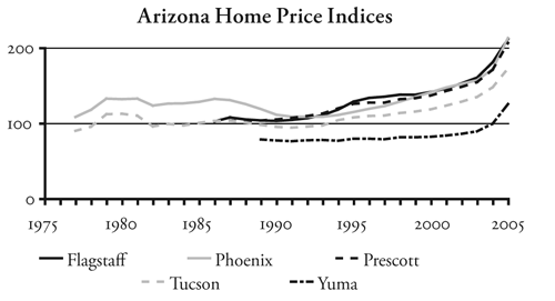
In 2000, Arizona voters solidly defeated a growth-management initiative that, opponents warned, would lead to unaffordable housing. But Arizona’s legislature had already passed two “growing smarter” bills promoting the preservation of open space—obviously a vital concern in a state that, by 1997, was already all of 2 percent developed.40 To help protect the remaining 98 percent, Flagstaff voters approved a regional urban growth boundary in the late 1990s. Phoenix and Tucson took other steps to protect open space. The result was that housing prices rapidly increased despite the defeat of the 2000 growth measure.
Arizona’s four metropolitan areas have total planning penalties of just under $80 billion. The Phoenix-Mesa area alone accounts for $65 billion of this total.
Mountain States
Albuquerque, New Mexico planning penalty: $11,000
Missoula, Montana planning penalty: $64,000
Santa Fe, New Mexico planning penalty: $94,000
Salt Lake City, Utah planning penalty: $18,000
While 2 percent of Arizona and 2.5 percent of Colorado have been developed, the rest of the Rocky Mountain states remain at least 98.5 percent rural open space.41 Yet urban sprawl has become an issue in many regions of these states. The state of Utah has helped fund an Envision Utah program of promoting smart growth. Albuquerque’s city council passed a smart-growth ordinance in 2003. Sprawl has also become an issue in Boise and several other fast-growth cities in the mountains.
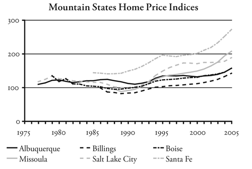
Santa Fe has strictly regulated development for decades, beginning with an ordinance requiring that all buildings in the city center be built in an adobe style. But smart growth in the Rockies was probably pioneered by Missoula, which passed a strict growth-management ordinance in 1999. Even before that, Missoula may have been the first city in the country to pass a minimum-density zoning ordinance aimed at promoting compact development. This 1990 ordinance was so strict that if a house burned down, the owner would be required to replace it with apartments.
Albuquerque’s city council recently approved a planned-growth strategy for the region. Salt Lake City and its suburbs have been urged by Utah’s governor to support smart-growth policies. The small planning penalties calculated for these urban areas reflect the recent adoption of these policies.
Midwest
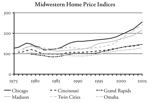
Minneapolis-St. Paul
Twin Cities planning penalty $32,000
The Twin Cities is one of the fastest-growing urban areas in the Midwest. The region’s metropolitan planning organization, known as the Metro Council, imposed an urban service boundary around the region in the mid-1970s. In the 1990s, the council adopted policies aimed at reducing sprawl. As a result, housing prices started rising in 1993, accelerating to 3 percent per year in 1996, and averaging more than 7 percent per year over the last seven years. As a result, the region is getting close to being marginally unaffordable. In 1997, the Minnesota legislature required all cities in the state to designate “urban growth areas,” thus ensuring that the rest of the state will become unaffordable as well.42
When Peter Bell, the chair of the Metro Council, spoke at the American Dream Coalition’s annual conference in the Twin Cities in 2005, he was asked how he could justify the price increases brought about by the urban service boundary. He said that it would cost thousands of dollars per home to extend services outside the boundary. As previously noted, The Costs of Sprawl 2000 estimates that low-density housing has urban service costs of about $11,000 more per home than compact development.43 It does not make sense that every homebuyer in the region should pay a median of $32,000 more in order to save $11,000 dollars on urban service improvements for new homes alone.
While the Twin Cities’ median planning penalty is still small, the large number of homes of the area means that the total planning penalty exceeds $33 billion. A lot of urban services could be provided for less than $33 billion.
Wisconsin
Kenosha planning penalty: $23,000
Madison planning penalty: $18,000
Milwaukee planning penalty: $20,000
In 1999, the Wisconsin legislature passed a Smart Growth Initiative, which gave cities incentives to write land-use plans aimed at conserving farmlands.44 Wisconsin metro areas were all affordable to very affordable in 1999 and most of them remained affordable in 2005. However, the affordability of Kenosha, Madison, and Milwaukee significantly declined in that time period.
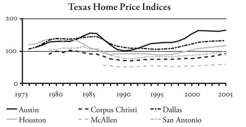
Texas
Home prices in Texas have fluctuated with oil booms and busts, so they remain about the same today as they were twenty-five years ago. Austin adopted a growth-management plan in 1980, which may explain why Austin prices since then have grown faster during booms and declined more steeply during busts. However, there is still no planning penalty in Austin’s housing prices, probably because housing has barely recovered from the decline in the late 1980s.
Texas housing markets are unusual in that they remained affordable in 1979, when interest rates were very high. This may be because an oil boom coincided with those high rates. With the oil busts of the late 1980s, prices descended into the very affordable range, and most Texas markets remain near the margin between affordable and very affordable today.
A comparison between Houston, which has no zoning, and Dallas, which does have zoning, suggests that zoning by itself does not contribute to unaffordable housing. But people in Austin should be concerned that the region’s growth-management plan is likely to make housing unaffordable soon.
Houston
Houston is often presented as a counter-example to growth-management planning because it has no growth management and no zoning. As a result, it has highly affordable housing and is one of the fastest-growing large urban areas in the country. Between the 1990 and 2000, it grew by nearly a million people, or about 2.8 percent per year.
As previously noted, Coldwell Banker says the average cost of its standard 2,200-square-foot house in Houston was $152,000 in 2005. Indeed, for about that price, you can currently buy a brand-new home very close to Coldwell Banker’s specifications in the Woodlands, an attractive development twenty-seven miles north of downtown Houston.45 This makes Houston one of the fifteen least-expensive housing markets of the 319 US regions examined by Coldwell Banker.
Houston’s fortunes are tied closely to the oil industry: when oil prices are high, Houston booms; and when oil prices are low, Houston busts. Houston did very well during the OPEC-induced oil crises during the late 1970s, when its average incomes surged well ahead of the rest of the US, but its economy tapered off when prices fell in the 1980s. This led to a 35 percent decline in housing prices. Since 1990, Houston has been growing rapidly, but inflation-adjusted housing prices still are 15 percent below the 1980 peak. Homeowners may not be fully aware of this because inflation has made it appear that prices today are higher than their 1980 peak.
The oil boom of the late 1970s coincided with a period of extremely high interest rates that discouraged homebuyers. While this made housing extremely unaffordable in many other cities, Houston housing merely became marginally affordable. Houston’s housing quickly recovered and has remained very affordable since then.
The index of Houston’s housing prices shows that prices have grown slightly faster than inflation at times, but in the long run have closely paralleled inflation. Over the past five years, when average US prices grew by 5.9 percent per year, Houston’s prices grew by a little more than half that amount, or 3.3 percent per year.
Dallas
Unlike Houston, Dallas does have zoning, but it has had little in the way of growth management. Zoning has responded to local residents’ desires to protect neighborhood values, which was the original intention of zoning when it was first conceived in the 1910s, rather than to planners’ desires to reshape. Dallas’ housing record is therefore similar to Houston’s except that Dallas is a bit less influenced by swings in the oil industry. But Dallas housing prices did fall by 27 percent between 1986 and 1995.
Like Houston, the Dallas–Fort Worth area grew by nearly a million people during the 1990s, yet the region maintained very affordable housing. Because of limitations in the data for Fort Worth, the following tables and charts are for Dallas only.
Dallas has consistently maintained family incomes about 10 percent above the US average, while its housing prices are generally lower than the US average. Dallas housing prices have been even less influenced than Houston’s by the recent housing boom: Over the last seven years, inflation-adjusted prices grew by just 2.4 percent per year. In 2005, the Coldwell Banker home that would cost $152,000 in Houston would cost $261,000 in Dallas but only $149,000 in Fort Worth.
Southeast
Outside of Florida, most regions in the Southeastern United States remain very affordable. Although Tennessee passed a Growth Policy Act in 1998, this law does not seem to have pushed prices upwards. Planning advocates complain that “the Act has not made much headway in encouraging cities and counties to plan more effectively for growth,” mainly because it left too much power to local authorities and not enough to the state to oversee their plans.46 This “failure” has allowed Tennessee to escape the consequences of growth-management planning.
In South Carolina, the state legislature authorized, but did not require, cities and counties to do growth-management planning. Charleston County passed a comprehensive plan aimed at preserving farmlands in 1999. Housing prices began to sharply increase at about that time.
Lexington, Kentucky was apparently the first American city to impose an urban service boundary, aimed at protecting Kentucky’s bluegrass farms, in 1958.47 Fayette County set a minimum lot size of ten acres outside the boundary. While Lexington has not become unaffordable as measured in this report, local critics say that high land costs within the urban growth boundary have encouraged developers to buy farms outside the boundary and subdivide them into ten-acre mini-farms. This arguably resulted in faster development of the rural landscape than quarter-acre lots might have done.48 The county’s response was to increase the minimum lot size to forty acres in 1999.49
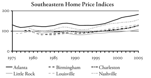
Atlanta
The Atlanta urban area grew by more than 1.3 million people during the 1990s, for a whopping 5.0 percent annual growth rate. Yet, like Houston and Dallas, Atlanta has been able to maintain fairly affordable housing. Atlanta’s economy is much more diverse than Houston’s, so it has not suffered a major decline in housing prices in the past several decades. Prices in the last seven years have grown by 3.5 percent per year, slightly more than Houston’s but considerably less than the national average.
Charleston, South Carolina
Charleston planning penalty: $7,000
Like the other southern regions in this paper, Charleston has maintained affordable housing over most of the period studied. However, in the late 1990s Charleston County and other counties in the Charleston area approved comprehensive plans that placed severe restrictions on development of agricultural lands. The result is that housing prices started rising at 7.0 percent per year, faster than the national average and more than twice as fast as most other southern regions. As a result, despite the low interest rates in recent years, Charleston housing is headed into the marginally affordable category.
The Coldwell Banker home that would cost $152,000 in Houston would cost more than $307,000 in Charleston. Charleston’s planning penalty of $7,000 per median-priced home adds up to $1.0 billion for all homes in the region.
Land-Ownership Penalties
Nevada does not have growth-management planning, and Hawaii did not have it in 1959. Yet Hawaii was unaffordable then just as Las Vegas and Reno are today. In these cases, the culprit is not planning but land ownership patterns. In Hawaii, government agencies and just seventy-two private entities own 95 percent of the land in the state.50 The private owners have historically chosen not to develop most of their land, which explains why Honolulu has been unaffordable for so much longer than any other region. Hawaii also has urban growth boundaries and a formidable planning process, but it is hard to estimate how much of the state’s unaffordability is due to planning and how much is due to the land problems that preceded planning. The total cost of these barriers to homebuilders is $59 billion in Honolulu alone; no doubt the cost for Hawaii as a whole is much more.
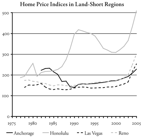
Nevada is the nation’s seventh-largest state, but the federal government owns nearly 90 percent of the land. The Bureau of Land Management has sold land to developers to provide room for Reno and Las Vegas to grow, but increasing resistance from environmental groups has slowed such sales in recent years. Such resistance might be considered a form of growth-management planning, and it explains why Nevada cities have become unaffordable despite the lack of any state or local growth-management planning. The resulting penalty for the Las Vegas and Reno housing markets comes to just under $64 billion.
Alaska is another state that may suffer from housing shortages for reasons other than growth-management planning. Both Alaska and Hawaii are distant from many raw material suppliers, and the cost of construction materials is higher than in the rest of the country. Though Alaska is the largest state, 99 percent of it is federal, state, or Native American land. Anchorage, the state’s largest city, is not as bad off as Juneau, but a land shortage may contribute to overpriced homes. The total penalty to Anchorage homebuyers is a modest $1.0 billion.
Discussion
Table 5 summarizes the findings of this report. Up until the 1960s, nearly all US metropolitan areas outside of Hawaii were affordable to most of the people who lived in those areas. Since then, housing prices in an increasing number of areas have grown out of proportion to family incomes. In most cases, the decade in which housing markets became unaffordable closely followed the approval of state growth-management laws or restrictive local plans.
Of course, correlation does not prove causation. Is growth-management planning really responsible for the unaffordable housing in so many regions? Or are other factors responsible? The remainder of this paper will discuss these questions and show that growth-management planning, rather than demand or the livability of a region, is the reason why so many metropolitan areas have become unaffordable.
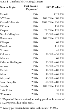
It’s Supply, Not Demand
Planning advocates often blame housing affordability problems on demand. “Market demand, not land constraints, is the primary determinant of housing prices,” claims one report.51 If this were true, then home prices would be much higher in Atlanta, Houston, and Raleigh, which are among the nation’s fastest-growing metropolitan areas, than they are in San Diego and San Jose, which are growing very slowly. In fact, the reverse is true: San Diego and San Jose home prices are many times greater than those in the faster-growing regions.
The truth is that demand is not the problem. No matter what the demand, the cost of existing homes is controlled by the cost of building new ones, and the cost of new homes depends on three factors: construction materials, labor, and land. At least in the contiguous 48 states, construction materials are sold on a national market, and except for very short-term situations, such as right after a major disaster, local material prices are not going to vary much from the national average, no matter what the local demand.
Labor is almost as mobile as materials. Labor costs may vary from region to region if the cost of living in one region is higher than in another. But in the contiguous 48 states, differences in the cost of living are due mainly to differences in housing costs. In other words, high labor costs may be an effect of high housing costs, but they are not the cause.
Land is the one factor of production that is not mobile. Despite worries about urban sprawl, land is the most abundant of these three factors. All urban areas in America, including clusters of as few as 2,500 people, occupy well under 3 percent of the land area of the United States. Counting even smaller towns and rural developments such as roads and railroads, 95 percent of the US remains rural open space.52 Only a handful of states are more than 10 percent developed and no state has a shortage of rural open space.53
In the absence of restrictions on land supply, homebuilders have proven themselves able to meet the demand for housing in the fastest-growing areas. San Jose grew by nearly 14 percent per year in the 1950s, yet housing remained affordable in 1959. Atlanta, Dallas, Houston, and Phoenix grew by at least 900,000 people in the 1990s, yet if anything their housing affordability increased during the decade.
Why, then, is housing so unaffordable in some areas and not in others? The answer is supply, or lack of it. Everyone needs a place to live, and owning a home is particularly valued for reasons of security, pride, and the flexibility to customize the home in ways that rented homes cannot be changed. Economists use the term inelastic to describe the demand when small changes in supply lead to a large change in price. Housing is an example of an inelastic good. One study calculated elasticities of demand for housing in US urban areas ranging from 0.36 to 0.41, concluding that a 1 percent decline in the supply of new homes can cause a 2.5 to 3 percent increase in prices.54 In short, small restrictions on the supply of new housing can lead to large increase in price.
All over the United States, growing cities attract people because of the beauty of their natural surroundings, the congeniality of their residents, and their stimulating cultural atmospheres. At some point as these cities and regions grow, someone says, “If we are not careful, we are going to end up like [insert name of nearest congested megalopolis here]. We better take action to preserve the wonderful livability of our community.”
The typical result is a growth-management plan aimed, its adherents say, at protecting and enhancing livability. Soon after the plan is implemented, housing prices sharply increase. Planning advocates attribute this increase to the growing demand for such livable communities. “We passed the new planning rules just in time,” they say. “The rules must be working,” they add, “because look at how much people are willing to pay to live in our community!”
If the plan is a smart-growth plan, it probably calls for more compact development and multifamily housing. Of course, most of the plan’s supporters already own their own homes on large lots. Just as satirical newspaper The Onion once reported that “98 percent of US commuters favor public transportation for others,”55 many supporters of compact cities want density for someone else. Though 70 percent of their community may currently live in single-family homes, they see nothing wrong with dictating that, say, half of all future inhabitants will have to live in multifamily housing. “You are going to love living on our lively streets,” they say before they get into their SUVs and drive to their suburban estates.
The first growth-management policies date at least as far back as the fifteenth century, when Queen Elizabeth, who could leave London for a suburban or exurban palace whenever she wanted, drew an urban growth boundary around London and dictated that no development could take place outside the boundary.56 The policy obviously failed to prevent London from sprawling. But after World War II, the British Parliament made another attempt to stop sprawl when it passed the Town & Country Planning Act of 1947, which purchased large greenbelts around London and other cities, nationalized most home construction, and focused construction on high-rise apartments rather than single-family homes.57
Many other European nations, both west and east, enacted similar policies aimed both at limiting urban sprawl and encouraging people to walk, bicycle, or use transit rather than drive automobiles. Initially, construction of public housing, even in the form of tiny apartments in concrete towers, was welcomed in war-ravaged cities. Yet polls have consistently shown that Europeans, like Americans, aspire to live in their own single-family homes.58 By the mid- to late-1960s, the residents of many Western European democracies had had enough, and they successfully overturned many of the plans in England,59 Sweden,60 and other countries. Since then, their cities have been decentralizing and auto driving has been increasing just like in the United States. In Eastern Europe, the fall of the Soviet empire led hundreds of thousands if not millions of people to abandon their high-rise apartments for low-density towns and suburbs.61
Even as Western Europeans were overturning their growth-management policies, American cities began adopting similar policies, often with a stated goal of emulating Europe’s example. Boulder, Colorado approved a greenbelt in 1967. Ramapo, New York became the first city to adopt a concurrency ordinance in 1970. In 1972, Petaluma, California decided to issue no more than 500 building permits a year. Boulder soon followed with an ordinance limiting new permits to allow its population to grow by no more than 2 percent per year. Cities and counties in California, Hawaii, Oregon, and Vermont drew urban growth boundaries in the 1970s, starting with San Jose and Santa Clara County in 1974.
Growth management and unaffordable housing are not confined to the United States and Europe. Wendell Cox observes that most housing markets in Australia and New Zealand have become severely unaffordable, and that cities in these countries practice various forms of growth management. Vancouver, BC, is heralded for having Canada’s strongest smart-growth plans, including agricultural land reserves and other restrictions on housing development, and not coincidentally it is also has Canada’s least affordable housing. Cox found that, “among the ‘severely unaffordable’ urban areas” around the world, “23 of the 26 are subject to strong smart-growth policies.”62
The Demonization of Sprawl
Advocates of growth management usually argue that their policies are needed to prevent sprawl. Sprawl, a pejorative term for low-density suburban development, has been so thoroughly demonized that people take for granted that any policy that opposes it must be a good thing. While a detailed review of the benefits and costs of sprawl is beyond the scope of this paper, it is worth noting that sprawl causes far fewer problems than the so-called remedies to it.
- Sprawl is the cure for, not the cause of, congestion. As USC planning professors Peter Gordon and Harry Richardson observe, “suburbanization has been the dominant and successful mechanism for coping with congestion.”63
- By providing access to low-cost land, sprawl increases, not reduces, housing affordability.
- As the US Department of Agriculture says, urbanization is “not considered a threat to the nation’s food production.”64 Nor is it a threat to forests or other rural open spaces.
- Sprawl does not make people “auto dependent.” Rather, it gives people opportunities to take advantage of the liberating effects of automobility. The effects of automobiles include a huge increase in real personal incomes, access to a wide variety of low-cost consumer goods, and increased recreation and social opportunities.65
- Sprawl does not make people fat or unhealthy, and claims to the contrary are based on junk-science reports that find weak correlations between statistically questionable data and then assume that correlation proves causation.66
- Sprawl does not cause toxic air pollution. Concentrations of toxic pollutants are far more likely in dense areas than in low-density areas.
Policies aimed at stopping sprawl tend to make places more congested, more polluted, and more expensive without providing any significant benefits. Rather than adopting these policies without question, public officials and voters need to ask whether the benefits of such policies will really exceed the costs; who will benefit and who will pay; and whether the policies unfairly add to the burden of low-income families who are trying to achieve the American dream.
Livability vs. Affordability?
Does growth-management planning offer a trade-off between livability and housing affordability? Or are smart growth’s claims of livability as hollow as its claims of affordability? A detailed assessment of livability is beyond the scope of this paper, but the following points are worth noting.
The first issue to address is the so-called cost of sprawl. Planners say that it costs more to provide urban services to low-density areas, so compact development will be more affordable. Yet the most detailed analysis of this claim, The Costs of Sprawl 2000, found that low-density development adds only about $11,000 to the cost of a new single-family home.67 In contrast, this paper found 115 metropolitan areas that have imposed planning penalties on all of the homebuyers in their regions that are greater than $11,000 per home. The average penalty in these regions is $130,000.
Another way planners say they can improve livability is by dealing with traffic congestion. A recent poll found that residents of the Portland area considered traffic congestion to be one of “the three most key issues facing the region.” At the same time, 61 percent of the people polled considered themselves “very supportive” or “somewhat supportive” of planning efforts in the region.68 Many of the people being polled probably did not know that Portland planners have done their best to increase, not reduce, traffic congestion.
“Congestion signals positive urban development,” says Portland’s regional planning agency.69 “Transportation solutions aimed solely at relieving congestion are inappropriate.”70 When publicly asked why the agency found high levels of congestion to be acceptable, its leading transportation planner replied that any effort to relieve congestion “would eliminate transit ridership.”71
Planners increase traffic congestion through so-called traffic calming, the replacement of auto lanes with bike or streetcar lanes, the diversion of road construction funds to rail transit, and deliberate decisions not to build new roads even if funds are available. The result wastes thousands of hours of people’s time each day and unnecessarily burns millions of gallons of fuel per year, which can hardly be said to increase livability. Congestion also increases consumer costs as it increases the cost of delivering goods to markets.
Nor is there much evidence that smart growth has a significant effect on driving habits. Per capita driving in Portland, San Jose, and other cities that have adopted smart-growth plans is growing as fast or faster than in other parts of the United States. While people who live in high-density developments may drive a little less, it is usually because those developments attract people who want to drive less. Once this market is saturated, new residents in these developments drive as much as anyone else. In fact, experiences in Portland have shown that so-called transit-oriented developments only work if they have plenty of parking.72
Smart growth also requires higher taxes or reduced urban services to subsidize high-density housing, rail transit, and other utopian planning projects. A recent poll found that 82 percent of Americans aspire to live in a single-family home in the suburbs, while only 18 percent want a “home in the city, close to work, public transportation, and shopping.”73 This means subsidies are usually needed to achieve smart growth’s goal of increasing high-density urban housing. Such subsidies are often in the form of tax-increment financing, where property taxes that would ordinarily go to schools, libraries, fire, and police are instead spent subsidizing unmarketable housing. The residents of these cities either suffer reduced urban services or are asked to cough up more taxes for schools and other programs that are ordinarily paid for by property taxes. Portland has diverted so many property taxes to light rail and transit-oriented developments that its mayor recently proposed a city income tax to help pay for schools.
Unaffordable housing creates its own problems. When locating new offices or factories, employers look for places where their employees can afford housing on the salaries or wages the employers can pay. It is no surprise that Portland and San Jose, two cities that have adopted the strongest smart-growth plans in the country, had the first- and second-highest unemployment rates during 2001 and 2002. Unaffordable housing also leads to “childless cities,” as families with children move to distant suburbs where they can afford a home with a yard. Ironically, this is forcing Portland to close three to four schools a year even as its suburbs construct new ones.74
Some people rank urban livability by the number of bike paths a city has or the number of people who can walk from home to a coffee shop. But if most people continue to drive for most of their trips, such numbers are meaningless. It is hard to imagine that more traffic congestion, higher taxes, lower urban services, increased consumer costs, and unaffordable housing add up to a more livable city.
Climate issues aside, is San Jose really more livable than San Antonio? If you take away the youth culture created by the University of Colorado, would Boulder really be more livable than Colorado Springs? If heavily-planned Portland is so much more livable than lightly planned Vancouver, Washington, then why did Vancouver grow by 210 percent in the 1990s when Portland grew by only 22 percent? These sorts of questions cast strong doubts on claims that smart growth or other growth-management planning rules produce sufficient livability benefits to compensate for the unaffordable housing they create.
Winners and Losers
At first glance, it might seem that overpriced housing is a zero-sum game—one in which losers are exactly balanced by winners—because for every homebuyer who loses, a home seller wins. However, it turns out that there are more losers than winners, total losses are much greater than total gains, and the greatest losses are unfairly imposed on those members of society who are least able to afford those losses.
Home sellers win only if they are trading down to a less expensive home or are moving to a less overpriced region of the country. Home sellers lose if they want to trade up to a more expensive home or must move to a more overpriced region. So a substantial fraction of the supposed winners are actually losers.
While homeowners also appear to win if they can borrow against the increased equity in their homes, they must eventually repay that equity so this gain is slight. Growth management also makes housing prices more volatile.75 This means people who borrow against artificially inflated home values face the risk that prices will deflate after the bursting of a housing bubble, leaving them with a mortgage greater than the actual value of their house.
Growth-management planning creates more losers than just the homebuyers. People who own land outside of urban growth boundaries or land that is otherwise downzoned as part of the growth plan also lose a substantial portion of the value of their land. In Portland and San Jose, an acre of land inside the boundary can easily be worth one hundred times more than an otherwise similar acre outside the boundary. Were it not for the boundary, the acres inside would be worth less and those outside would be worth more. Some forms of growth-management planning attempt to compensate some of these landowners by purchasing conservation easements or the land itself, But often this compensation is offered only after the value of the land has been reduced through downzoning, so the landowners are not really fully compensated.
In a given urban area, the people who own their homes tend to have higher incomes than those who do not. When growth-management planning erects barriers to first-time homebuyers, those barriers affect low-income people the most. So not only do the number of losers outnumber the winners, the losses are unfairly distributed more to low-income families.
Do Planners Know?
Do planners deliberately drive up land and housing costs in order to force more people to live in planners’ utopian compact cities? Or do planners really believe that they can manage growth without affecting housing prices? A “yes” answer to either question does not reflect well on the planning profession. If the former is true, planners are being totally deceitful and imposing huge costs on society for the questionable goal of preserving open space in a country that is, after all, 95 percent rural open space. If the latter is true, then planners are incompetent idiots who could not be trusted to manage a fast-food restaurant, much less land use for an entire city or region.
These questions are worth noting because, as noted above, planners clearly are deceptive when it comes to traffic congestion. In public, they claim their plans will reduce congestion, when the plans themselves, and the planners when they talk among themselves, make it plain that their real goal is to increase congestion in order to persuade people to drive a little less.
With respect to housing, however, planners rarely say, even among themselves, that one goal of growth-management planning is to drive up housing prices in order to discourage people from living on large lots. One rare exception recently took place in Portland, Oregon, when real estate professionals noted that suburban land values had reached a “tipping point” where it was now worthwhile for developers to buy suburban single-family homes and replace them with high-density housing.76 The 1997 regional plan for Portland had directed that two dozen cities and three counties in the region rezone some neighborhoods to higher densities in anticipation of this point being reached. Yet nothing in the plan itself, or any of the supporters of the plan, ever mentioned that a goal of the plan was to increase land values.
One way that planners confuse the issue is by using the term affordable housing instead of housing affordability. Housing affordability refers to the general price level of housing in a community relative to family or household incomes. Affordable housing refers to a few housing units priced below market value, usually through government mandates or subsidies. While everyone in a region benefits from housing affordability, government-subsidized or mandated affordable housing benefits only a few, and costs everyone else in the form of taxes or higher housing prices so that builders can fulfill their mandates.
In discussing affordable housing, planners will often say something like, “High-density, mixed-use developments provide affordable housing.” Naturally, smaller dwelling units with shared walls will tend to be less expensive than larger and more private single-family homes. But that does not mean that the affordability of housing in a region is improved by the construction of such dense housing, especially if the construction is partly inspired by land-use regulations that drive up other housing costs.
The Wrong Solution
When planning-induced housing shortages make homeownership unaffordable, planners typically propose the entirely wrong solutions to the problem. Instead of recognizing that their own rules are driving up housing costs, they in effect, and sometimes in fact, blame the developers and homebuilders who are trying to meet the demand for housing. One planning solution to high-priced housing is inclusionary zoning, which requires that developers who build more than so many homes at one time dedicate a certain percentage of those homes to “affordable housing.”
The first problem with inclusionary zoning is that it makes housing affordable for only a tiny percentage of people, while growth-management planning makes housing unaffordable for everyone. Homebuilders increase the nation’s housing supply by less than 2 percent per year; only some of the homes built are in developments large enough to meet the threshold for affordable housing; and generally less than 20 percent of the homes in such developments are dedicated to affordable housing.
The second problem with inclusionary zoning is that it has the perverse effect of driving up housing prices for everyone who is not lucky enough, or well-connected enough, to get one of the below-market homes. To cover their losses from below-market homes, homebuilders must increase the price of the remaining homes in their developments. When owners of existing homes see new home prices rise, they naturally ask more for their homes. This means that the amounts saved by a few are more than offset by the extra amounts paid by everyone else.77
Another solution is to provide subsidies to low-income housing. This has the same problems as inclusionary zoning: subsidies help very few people and they sometimes add to everyone else’s housing costs. San Diego, for example, finances subsidized housing with a “housing impact fee” charged to developers—who, of course, pass the cost onto homebuyers. A city of 470,000 homes, San Diego has used this fee to subsidize only 6,700 homes since 1990.
Subsidies can also be inequitable: San Jose uses federal funds to subsidize housing for “below median-income families.” But San Jose’s median-family income is $105,000 per year, while the national median income is only $58,000. This means taxes paid by US families earning $50,000 or $60,000 per year are used to subsidize San Jose families who earn $100,000 a year.
Inclusionary zoning and housing subsidies are really nothing more than ways for planning advocates to relieve consciences guilty about driving up housing costs. These policies do more harm than good to the housing markets that use them. “If policy advocates are interested in reducing housing costs,” economists Edward Glaeser and Joseph Gyourko observe, “they would do well to start with zoning reform,” not affordable-housing mandates or subsidies.78
Conclusions and Recommendations
This paper has shown that housing prices sharply rise and housing affordability declines soon after cities or regions impose various forms of growth-management planning, such as urban growth boundaries, limitations on building permits, or other rules or processes that restrict homebuilders’ ability to meet the demand for housing. These rules have added tens of thousands of dollars to the median cost of housing in more than one hundred metropolitan areas and hundreds of thousands of dollars to the median cost of housing in nearly fifty metropolitan areas.
This report conservatively estimates that growth-management planning has added $5.5 trillion to the cost of owner-occupied homes, with annual costs to homebuyers of $275 billion. This is on top of costs to renters and purchasers of commercial, retail, and industrial property.
These costs are far greater than any possible benefits from such planning. The most popular report on the costs of sprawl estimates such costs to be about $11,000 per new suburban home.79 This is far outweighed by the planning penalties imposed on homes in more than one hundred metropolitan areas of the United States. Besides, most Americans would be glad to pay an extra $11,000 on a $150,000 home to be able to live in a neighborhood of their own choosing rather than in an expensive, high-density development that planners prefer.
One of the most disturbing aspects of the planning penalty is its regressive nature. Growth-management planning especially penalizes low-income families and first-time homebuyers, while it provides windfall profits for wealthy homeowners. According to the Federal Reserve Board, median family net worth was $93,100 in 2004, while mean family net worth was $448,200. This massive difference between median and mean says that a great deal of the nation’s wealth is concentrated in the hands of a relatively small share of the population. Moreover, the Federal Reserve Board found that mean net worth is growing twice as fast as median net worth, which means that the rich are getting richer faster than everyone else.80
The planning penalty greatly contributes to this trend. In scores of metropolitan areas, first-time homebuyers must pay planning penalties that are significantly greater than the median family net worth. The penalty denies the benefits of homeownership to many low-income families and often forces them to pay higher rents. The winners are the wealthy homeowners and landowners who already own most of the nation’s assets. The sad irony is that many of the regions and communities adopting these highly regressive policies, such as Boulder, Missoula, Portland, and the San Francisco Bay Area, consider themselves to be at the forefront of the progressive movement.
The problems that growth management is supposed to solve can be better addressed through private means or other non-regulatory tools. States and cities that have not yet adopted growth-management laws or ordinances should avoid them. States and cities that have adopted such measures should repeal them.
Urban growth and urban service boundaries increase urban congestion by concentrating driving in smaller areas and drive up housing costs by creating artificial scarcities of land. They are not needed to protect farms, forests, or open space; as the Willamette Valley Livability Forum study showed, because rural areas are so extensive and urban areas so small, growth boundaries have a trivial effect on rural spaces even as their effects on urban areas are huge.
Neither is there justification for limits on the number of building permits issued each year, the large-scale purchases of greenbelts or other open spaces, or other government programs aimed at limiting sprawl. The real effect of these programs is to deny homeownership to low-income families. “What has happened,” observes Stanford University economist Thomas Sowell,” is that those already inside the castle have pulled up the drawbridge, so that outsiders can’t get in.”81
Instead of relying on boundaries, large-lot rural zoning, open space purchases, or other government programs, open space protection should be left to private individuals and organizations. With 95 percent of the country remaining as rural open space, open space is simply not a government priority compared with such things as schools, fire, police, and other more fundamental concerns. That does not mean there is no need to protect selected open spaces, but land trusts or other privately funded organizations are the best means of targeting and protecting such spaces, not the heavy hand of government.
Zoning should focus on the purpose for which it was originally designed: the protection of neighborhood quality. The people who designed the first zoning codes realized that the value of people’s homes in a neighborhood depended in part on how their neighboring properties were used. Some restrictions on property rights would actually enhance the total value of properties in the neighborhood.82 Growth management goes far beyond this purpose and uses zoning to try to socially engineer utopian changes in urban areas.
A neighborhood zoning system gives residents a great deal of say about what happens in their own neighborhood. As prospective developments get further away from a neighborhood, however, they have a progressively smaller effect on neighborhood values. Planning processes that give anyone an opportunity to challenge developments, no matter how slight an impact the development may have on the challenger, can create onerous delays to developers and drive up housing prices.
As University of San Diego law Professor Bernard Siegan observes, homeowner associations and protective covenants can provide the benefits of neighborhood zoning without the risks of utopian social engineering.83 University of Maryland public policy Professor Robert Nelson suggests that legislatures allow homeowner associations to opt out of city zoning and take over the planning and management of their neighborhoods.84 Nelson even suggests that rural landowners form neighborhood associations to allow farmers and landowners, rather than developers or government planners, manage the pace of rural development.85
Concurrency requirements are an abdication of responsibility: Instead of figuring out how to accommodate new families, planning boards can simply pretend that their city or region is not growing. Impact fees are supposed to provide the funds needed to cover the costs of growth. But too often, both concurrency rules and impact fees are used to prevent or penalize growth rather than manage it.
Virginia’s new governor, Timothy Kaine, recently proposed that the legislature “slow sprawl” by giving cities the authority to reject proposed developments if they would “overwhelm roads and infrastructure.”86 On the theory that sprawl is more costly than compact development, San Diego charged stiff impact fees in suburban areas but waived the fees in the city. Within a decade, the resulting infill developments led to a billion-dollar shortfall in funding for infrastructure.87
Growth may or may not pay for itself in California, where voters have strictly limited property taxes. But it usually does pay for itself in most other places. A study in South Carolina found that tax revenues from several proposed new developments “will exceed the estimated added annual costs for each of the eleven cities, counties, and school districts in which the subdivisions are located.”88 A study in Oregon found that low-density developments were much more likely to pay for themselves than high-density developments.89 This really should not be surprising since property taxes are generally designed to cover both the capital and operating costs of schools, water, sewer, and other public utilities. Where people are worried that growth may not pay for itself, the problem may best be solved by creating special service districts for the growing areas rather than by attempting to slow growth or suburbanization.
In sum, neighborhood zoning, homeowner associations, and sensible financial structures are better tools for dealing with growth than growth boundaries, onerous planning processes, and concurrency requirements or impact fees. States and regions that have not adopted growth-management policies should use these tools instead. States and regions that have adopted growth-management policies should repeal those laws or ordinances and replace them with policies that will not drive up housing costs or produce other unintended consequences.
This recommendation will be most difficult to apply in California, the greater Boston, New York, and Washington, DC metropolitan areas, and a few other places such as Boulder, where planning penalties on median-priced homes are in the hundreds of thousands of dollars. Homeowners may fear that abandoning the policies could lead to a drastic fall in the value of their homes. But the reality is that housing prices are unsustainably high today in any case, and those prices will fall. Eliminating the policies that drove up the housing prices in the first place will make sure that the current housing bubble is not repeated.
One important role California and the other hyper-inflated housing markets can play is as object lessons for the rest of the country. Attempting to manage growth is like playing with fire: the unintended consequences are likely to be much greater than any actual benefits.
Homeownership helps Americans create wealth, educate their children, and gain self-esteem. While some may question whether government should try to increase homeownership through subsidies, no one should support policies aimed at reducing it by making housing unaffordable. Such barriers to homeownership can only be regarded as un-American.
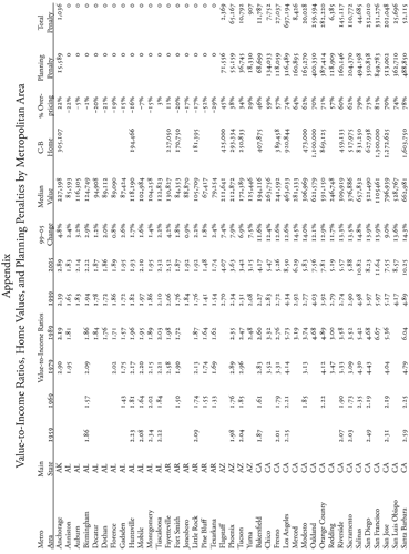
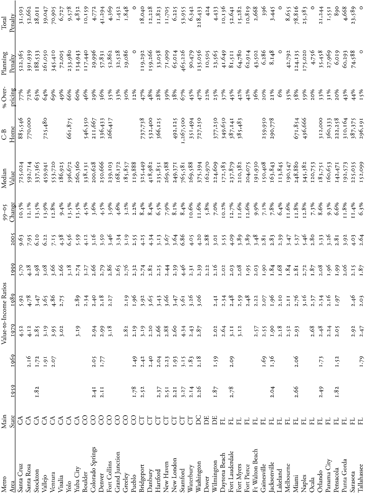
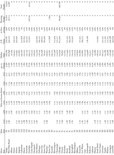
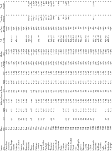
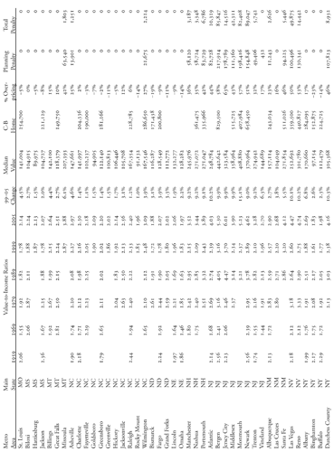
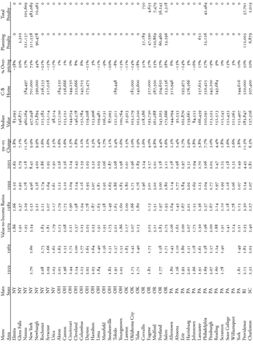
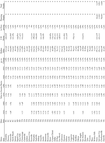
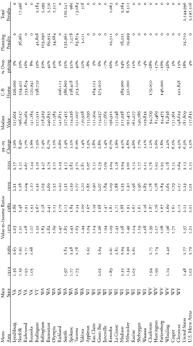
Explanation of Columns
Value-to-income ratios for 1959 through 1999 equal Census Bureau estimates of median home values divided by Census Bureau estimates of median family incomes, adjusted to 2005 dollars using gross-national product price deflators.
Value-to-income ratios for 2005 equal 1999 median-home values adjusted to 2005 using Office of Federal Housing Enterprise Oversight home price indices divided by 2005 median family incomes published by the Department of Housing and Urban Development.
99-05 Change shows the average annual growth (or, in one case, decline) in prices between 1999 and 2005.
Median Value is the 2005 median-home value calculated as noted in the value-to-income ratios for 2005 above.
C-B Home is Coldwell Banker’s estimate of the cost in 2005 of a 2,200-square-foot, four-bedroom, two-and-one-half bath, two-car garage home with a family room in a neighborhood that is typical for corporate middle managers. Coldwell Banker’s estimates are for individual cities, not metropolitan areas, so will not necessarily be proportionate to mean values. For the New York metro area, the number shown here is Coldwell Banker’s number for Queens. For one reason or another, Coldwell Banker did not estimate a price for some central cities, such as Los Angeles and Philadelphia, so this paper used the price for a typical suburb of those cities (e.g. Long Beach for Los Angeles). Coldwell Banker did estimate a price for Chicago, but it is much higher than would be expected from Chicago’s median home value, probably reflecting the realty company’s neighborhood selectivity.
% Overpricing is the percentage of 2005 home values in a region that is greater than a value-to-income ratio of 2.24. If a home costs $250,000 in a region that is 20 percent overpriced, then the value of that home “should” be $200,000 ($250,000 minus 20 percent). The 2.24 value-to-income ratio was based on the 1999 median metropolitan area home value increased by 2.5 percent per year to 2005 divided by the 2005 median metropolitan area family income.
Planning Penalty is the estimated amount in dollars that is added to a median-priced home due to growth-management planning (or, in a few cases, to land shortages caused by other factors) in 2005. This penalty assumes that houses may cost up to 20 percent more than would be expected from a value-to-income ratio of 2.24 for reasons other than growth-management planning, but that all additional costs are due to planning.
Total Penalty is the total added cost in millions of dollars of owner-occupied housing in a region due to growth-management planning in 2005. It is calculated from the Census Bureau’s 1999 aggregate value of owner-occupied housing, increased in price to estimate 2005 using the home price index and increased in numbers proportional to the population growth of each region through 2004. If an average of 5 percent of a region’s housing stock is sold each year, then divide the total penalty figure by 20 to estimate the annual cost to homebuyers of growth-management planning.
Glossary
The following glossary of terms includes:
- Census terms listed in bold; definitions in quotation marks are from the Census Bureau.90
- Common planning and housing terms listed in Roman face, though the definitions may be exclusive to this report;
- A few terms that are unique to this report listed in italics.
affordable housing: Specific units of housing built for or subsidized to be affordable to families whose incomes are less than the median income for a city or region. Contrast with housing affordability.
central city: “In a metropolitan area (MA), the largest place and, in some areas, one or more additional places that meet official standards issued by the federal Office of Management and Budget. A few primary MSAs [see metropolitan statistical area] do not have a central city.”
consolidated metropolitan statistical area (CMSA): “If an area that qualifies as a metropolitan statistical area has a census population of 1 million or more, two or more primary metropolitan statistical areas (PMSAs) may be designated within it. When PMSAs are established within a metropolitan area, that metropolitan area is designated a consolidated metropolitan statistical area (CMSA).”
concurrency: A law or rule that states that planning boards may or must deny permits for new developments if roads, schools, or some other infrastructure is not adequate to support that development.
downzone: Zoning or rezoning a parcel to a more restrictive use, such as increasing the minimum lot size from ten acres to forty acres.
family: “A family includes a householder and one or more other people living in the same household who are related to the householder by birth, marriage, or adoption.”
growth management: Any land-use plan, policy, or regulation that aims to control or influence where or how fast development will take place, often with the stated goal of controlling urban sprawl or ensuring adequate financing of urban services.
household: “A household includes all of the people who occupy a housing unit.”
housing affordability: A measure of the affordability of all the housing in a region to the people living in that region. Housing is generally considered unaffordable if people must spend more than 30 percent of their incomes on it. Since housing costs include insurance, property taxes, and other costs in addition to a mortgage, this paper uses 25 percent as the threshold for a mortgage alone.
impact fee: A fee or fees charged to cover the capital costs of the infrastructure needed to support new development; sometimes the fees are used more as a punitive measure than as a financial measure.
large-lot zoning: In rural areas, zoning into parcels of 10 to 160 or more acres with the aim of limiting development of those areas.
mean: “The arithmetic average of a set of numbers.”
median: “The middle value in a set of numbers.” For example, if a small town has five homes valued at $100,000, $110,000, $120,000, $150,000, and $200,000, the median is $120,000 but the mean is $136,000. For incomes and home values, means are usually higher than medians because a few high incomes or expensive homes increase the means without increasing the medians.
metropolitan area: Although the Census Bureau has a slightly different definition, in this report, metropolitan area and metro area are used interchangeably with metropolitan statistical area.
minimum-density zoning: A zoning ordinance that requires development to equal or exceed some density of housing or other use.
metropolitan statistical area (MSA): “A geographic entity designated by the federal Office of Management and Budget for use by federal statistical agencies. An MSA consists of one or more counties, except in New England, where MSAs are defined in terms of county subdivisions (primarily cities and towns).” Generally, MSAs are defined to include urbanized areas of 50,000 people or more plus the rural portions of the counties that make up those areas. Minneapolis–St. Paul is an MSA with two central cities; a few primary MSAs have no central city.
overpriced: In this report, housing is considered overpriced if its median value is a greater multiple of median-family incomes than the standard value-to-income ratio.
percent overpriced: The percentage share of home prices that is greater than the standard value-to-income ratio.
planning penalty: The approximate amount of money growth-management planning has added to the cost of a median-value home.
primary metropolitan statistical area (PMSA): See consolidated metropolitan statistical area.
rural open space: Any land outside of urban areas that is not occupied by roads, railroads, or other developments larger than a quarter acre in extent.
sprawl: A pejorative term used to describe low-density development, especially development designed for optimal use of the automobile. When the term was first coined, it meant leapfrog development, that is, development that was not physically adjacent to existing cities. But in recent years the emphasis has been on whether the development is designed for the automobile, not on where it is located. Some anti-sprawl plans would even require leapfrog development so long as that development is auto-hostile.
standard value-to-income ratio: An estimate of what housing prices “should” be relative to family incomes. In census years (1959 through 1999), the standard ratio used in this report is the median value-to-income ratio across all metropolitan areas. For 2005, the standard ratio assumes prices increased by 2.5 percent per year from the 1999 census.
total penalty: The total amount of money that growth-management planning has added to the cost of all homes in a metropolitan area.
suburb: All developed areas in an urbanized area outside of the central city or cities.
urban area: “A generic term that refers to both urbanized areas and urban clusters.”
urban cluster: “A densely settled area that has a census population of 2,500 to 49,999.”
urban growth boundary: A line outside of which development is restricted by large-lot zoning.
urbanized area: “A densely settled area that has a census population of at least fifty thousand.” Generally, urbanized areas include all census tracts adjacent to central cities with population densities greater than about one thousand people per square mile.
urban service boundary: A line outside of which development is restricted by a refusal to provide water, sewer, or other urban services.
value-to-income ratio: The median-home value of a region divided by the median-family income in that region.
References
1. Census Bureau, “Housing Vacancies and Homeownership, Historical Tables, Table 14,” www.census.gov/hhes/www/housing/hvs/historic/histt14.html.
2. Paul Krugman, “That Hissing Sound,” New York Times, 8 August 2005.
3. Middle-managers’ home prices are based on Coldwell Banker, “Study Evaluates Cost Variances in 319 U.S. Markets,” 2 November 2005, http://hpci.coldwellbanker.com/hpci_press.aspx.
4. Edward L. Glaeser and Joseph Gyourko, The Impact of Zoning on Housing Affordability (Cambridge, MA: Harvard Institute of Economic Research, 2002), 3.
5. G. Donald Jud and Daniel T. Winkler, “The Dynamics of Metropolitan Housing Prices,” Journal of Real Estate Research, 23(1/2): 29–45.
6. Hernado de Soto, The Mystery of Capital: Why Capitalism Triumphs in the West and Fails Everywhere Else (New York: Basic Books, 2000), 6.
7. Joseph Harkness and Sandra Newman, “Differential Effects of Homeownership on Children from Higher- and Lower-Income Families,” Journal of Housing Research 14(1), 2003.
8. Donald R. Haurin, The Private and Social Benefits of Homeownership (Americus, GA: Habitat for Humanity University, 2003), http://www.habitat.org/hfhu/documents/haurinshow.pdf.
9. Ibid., 14.
10. Peter H. Rossi and Eleanor Weber, “The Social Benefits of Homeownership: Empirical Evidence from National Surveys,” Housing Policy Debate 7(1), 1996.
11. Randal O’Toole, “Is Urban Planning Creeping Socialism?” The Independent Review IV(4):505 (Spring 2000).
12. Jonathan Brinckman, “Builder thrives within boundaries: Arbor homes dominate as urban-growth limits keep national developers at bay,” The Oregonian, 1 September 2005.
13. Office of Federal Housing Enterprise Oversight, “House Price Index,” http://www.ofheo.gov/download.asp.
14. From www.census.gov. 1989 median family incomes are from table P107A and 1989 median home values are from table H061A of the 1990 census; 1999 median family incomes are from table P177 and 1999 median home values are from table H85 of the 1990 census. Data for 1959, 1969, and 1979 are from comparable tables in census books.
15. Housing and Urban Development, “FY 2005 Income Limits by Metropolitan Statistical Areas,” http://www.huduser.org/datasets/il/il05/Medians_2005.doc.
16. Federal Housing Finance Board, “Monthly Interest Rate Survey, Table 1: Terms on Conventional Single-Family Mortgages, Annual National Averages,” http://www.fhfb.gov/GetFile.aspx?FileID=4122.
17. From http://www.census.gov. Number of owner-occupied homes is from table H7; aggregate value is from table H86.
18. Coldwell Banker, “Study Evaluates Cost Variances in 319 U.S. Markets,” http://hpci.coldwellbanker.com/hpci_press.aspx.
19. White House, Historical Tables: Budget of the United States Government: Fiscal Year 2006 (Washington, DC: US GPO, 2005), 184–185, http://www.whitehouse.gov/omb/budget/fy2006/pdf/hist.pdf.
20. All adjustments for inflation are based on gross domestic product price deflators found in White House, Historical Tables: Budget of the United States Government: Fiscal Year 2006 (Washington, DC: US GPO, 2005), 184–185, http://www.whitehouse.gov/omb/budget/fy2006/pdf/hist.pdf.
21. Median home size is from 2000 census, table H027.
22. Bernard J. Frieden, The Environmental Protection Hustle (Cambridge, M.: MIT, 1979), 6.
23. Jason Johnson and Bernadette Tansey, “Voters Take Long Look at Sprawl,” San Francisco Chronicle, 4 November 1999, p. A-1, http://www.tinyurl.com/8xh5d.
24. Natural Resources Conservation Service, 1997 Natural Resources Inventory (Washington, DC: USDA, 2000), Table 1, www.nrcs.usda.gov/technical/NRI/1997/summary_report/table1.html.
25. Census Bureau, 2000 Census (Washington, DC: Department of Commerce, 2002), table GCT-PH1. For a spreadsheet comparing populations and land area of urban and rural areas from the 2000 census, www.americandreamcoalition.org/censusurbanareas.xls.
26. Hing Wong, Urban Growth Boundaries and Urban Limit Lines (Oakland, CA: Association of Bay Area Governments, 2006), 3, http://www.abag.ca.gov/jointpolicy/Urban%20Growth%20Boundaries%20and%20Urban%20Limit%20Lines.pdf.
27. David E. Dowall, The Suburban Squeeze: Land Conservation and Regulation in the San Francisco Bay Area (Berkeley, CA: University of California Press, 1984), 15.
28. Peter Fimrite, “Bay Area’s Open Space Tightrope,” San Francisco Chronicle, 5 June 2005, p. A-17, http://sfgate.com/cgi-bin/article.cgi?file=/c/a/2005/06/05/BAGROD3V5S1.DTL.
29. Robert Bruegmann, Sprawl: A Compact History (Chicago: University of Chicago Press, 2005), 65.
30. Nico Calavita, “Vale of Tiers: San Diego’s much-lauded growth management system may not be as good as it looks,” Planning magazine, March 1997, 18–21.
31. PMI, “Fall PMI Market Risk Index,” Economic and Real Estate Trends, fall 2006, 6, http://www.pmigroup.com/lenders/media_lenders/pmi_eret06v1s.pdf.
32. Edward Glaeser, Jenny Schuetz, and Bryce Ward, Regulation and the Rise of Housing Prices in Greater Boston (Cambridge, MA: Rappaport Institute, 2006), 1-ii–1-iii, http://www.ksg.harvard.edu/rappaport/downloads/housing_regulations/regulation_housingprices.pdf.
33. Ibid., 1–i.
34. Ibid., 1–iv.
35. PMI, “Fall PMI Market Risk Index,” Economic and Real Estate Trends, winter 2006, 6, http://www.pmigroup.com/lenders/media_lenders/pmi_eret06v1s.pdf.
36. New York State Division of Housing, History of Rent Regulation (Albany, NY: New York Division of Housing and Community Renewal, 1993), http://www.tenant.net/Oversight/50yrRentReg/history.html.
37. NRCS, 1997 Natural Resources Inventory, Table 1.
38. NRCS, 1997 Natural Resources Inventory, Table 1.
39. Willamette Valley Livability Forum, “Comparing Three Future Scenarios to 1990 Baseline Scenario,” The Willamette Chronicles, April 2001, 5. This publication can be downloaded from http://www.americandreamcoalition.org/WVLFtabloid.pdf. See also Randal O’Toole, “Public Funds Used to Distribute Smart-Growth Propaganda to Oregonians,” 2001, http://www.ti.org/vaupdate10.html.
40. NRCS, 1997 Natural Resources Inventory, Table 1.
41. Ibid.
42. Minnesota Statutes, 462.3535(1).
43. Robert Burchell, The Costs of Sprawl 2000, 13.
44. “Smart Growth Initiative,” Milwaukee Journal-Sentinel, January 2000, www.jsonline.com/news/state/jan00/smartgrowth013000.asp.
45. The Woodlands, www.thewoodlands.com.
46. Douglas Porter, Tennessee’s Growth Policy Act: Purposes, Implementation, and Effects on Development (Washington, DC: Growth Management Institute, 2002), 11, http://www.realtor.org/SG3.nsf/files/tengrowthpol.pdf/$FILE/tengrowthpol.pdf.
47. Kelly Kolakowski, Patricia L. Machemer, June Thomas, and Roger Hamlin, Urban Growth Boundaries: A Policy Brief for the Michigan Legislature (East Lansing, MI: MSU, 2000), 2.
48. Ed G. Lane, “(John or Joan) Public,” The Lane Report (Lexington, KY: kybiz.com, 1998), http://www.kybiz.com/lanereport/departments/oneonone/oneonone398.html.
49. Lexington-Fayette Urban County Government, “Fayette County’s Purchase of Development Rights Program and Rural Service Area Land Management Plan,” http://www.lfucg.com/administrativeservices/pdr/.
50. Teresa Tico, “A Brief History of Land Acquisition in Hawaii,” http://www.teresatico.com/presentations/history-of-land-acquisition/.
51. Arthur C. Nelson, Rolf Pendall, Casey J. Dawkins, and Gerrit J. Knaap, The Link Between Growth Management and Housing Affordability: The Academic Evidence (Washington, DC: Brookings Institution, 2002), 6.
52. Census Bureau, 2000 Census, table GCT-PH1. For a spreadsheet comparing populations and land area of urban and rural areas from the 2000 census, www.americandreamcoalition.org/censusurbanareas.xls.
53. NRCS, 1997 Natural Resources Inventory, Table 1.
54. Eric A. Hanushek and John M. Quigley, “What Is the Price Elasticity of Housing Demand?” The Review of Economics and Statistics, 62(3): 449–454, http://www.tinyurl.com/766wq.
55. “Report: 98 Percent of U.S. Commuters Favor Public Transportation for Others,” The Onion, 29 November 2000, http://www.theonion.com/content/node/38644.
56. Robert Bruegmann, Sprawl: A Compact History (Chicago: University of Chicago Press, 2005), 169.
57. Peter Hall, Cities of Tomorrow: An Intellectual History of Urban Planning and Design in the Twentieth Century (Cambridge, MA: Blackwell, 2002 edition), 239.
58. Bruegmann, Sprawl, 201.
59. Ibid., 179.
60. Ibid., 874.
61. Randal O’Toole, Smart Growth and the Ideal City (Bandon, OR: Thoreau Institute, 2005), http://www.ti.org/vaupdate53.html.
62. Wendell Cox, “Unprecedented Housing Unaffordability Strongly Associated with Smart Growth Policies,” http://www.demographia.com/dhi-200502.htm. See website for data.
63. Peter Gordon and Harry Richardson, “Congestion Trends in Metropolitan Areas,” in National Research Council, Curbing Gridlock: Peak-Period Fees to Relieve Traffic Congestion (Washington, DC: National Academy Press, 1994), 2:1–31.
64. NRCS, 1997 Natural Resources Inventory, Table 1.
65. Randal O’Toole, Transportation Costs and the American Dream (Bandon, OR: Thoreau Institute, 2003), http://www.ti.org/vaupdate41.html.
66. Randal O’Toole, The Myth of the Fat Suburbanite (Bandon, OR: Thoreau Institute, 2002), http://www.ti.org/vaupdate25.html.
67. Robert Burchell, et al., The Costs of Sprawl 2000, 13.
68. Davis, Hibbitts & Midghall, Metro Public Opinion Research (Portland, OR: Davis, Hibbitts & Midghall, 2006), 1–2.
69. Metro, Regional Transportation Plan Update (Portland, OR: Metro, March 1996), 1–20.
70. Metro, 1999 Regional Transportation Plan (Portland, OR: Metro, November, 1999), 6–38.
71. Metro, “Minutes of the Metro Council Transportation Planning Committee Meeting,” 18 July 2000, 7.
72. John Charles, The Mythical World of Transit-Oriented Development (Portland, OR: Cascade Policy Institute, 2001), http://www.cascadepolicy.org/pdf/env/P_1019.htm.
73. National Family Opinion, Consumers Survey Conducted by NAR and NAHB (Washington, DC: National Association of Realtors, 2002), 6, http://www.realtor.org/publicaffairsweb.nsf/ca2dae5fa466338d862567e6004ad5ff/cbf4f1aebd322cc985256ba30065ae7a/$FILE/survey-results.doc.
74. Clifton R. Chestnut and Shirley Dang, “Suburbs drain city schools,” The Oregonian, 12 October 2003.
75. Alan W. Evans and Oliver Marc Hartwich, Unaffordable Housing: Fables and Myths (London, England: Policy Exchange, 2005), 9.
76. Dana Tims, “Land value ‘tipping point’ hits suburbs,” The Oregonian, 20 October 2005.
77. Benjamin Powell and Edward Stringham, Housing Supply and Affordability: Do Affordable Housing Mandates Work? (Los Angeles, CA: Reason Foundation, 2004), 30–31.
78. Glaeser and Gyourko, Impact of Zoning on Housing Affordability, 21–22.
79. Robert Burchell, et al., The Costs of Sprawl 2000, 13.
80. Brian K. Bucks, Arthur B. Kennickell, and Kevin B. Moore, “Recent Changes in U.S. Family Finances: Evidence from the 2001 and 2004 Survey of Consumer Finances,” Federal Reserve Bulletin, 2006, p. A8, http://www.federalreserve.gov/pubs/bulletin/2006/financesurvey.pdf.
81. Thomas Sowell, “Easy Money in California,” townhall.com, 2005, http://www.townhall.com/opinion/columns/thomassowell/2005/04/19/15160.html.
82. Robert Nelson, Zoning and Property Rights: An Analysis of the American System of Land-Use Regulation (Cambridge, MA: MIT, 1977), 168–169.
83. B. H. Siegan, Land Use Without Zoning (Lexington, MA: Lexington Books, 1972), xv.
84. Robert Nelson, Private Neighborhoods and the Transformation of Local Government (Washington, DC: Urban Institute, 2005), 265–267.
85. Robert Nelson, “Privatizing the Neighborhood: A Proposal to Replace Zoning with Collective Property Rights to Existing Neighborhoods,” in David T. Beito, Peter Gordon, and Alexander Tabarrok (eds.), The Voluntary City: Choice, Community, and Civil Society (Oakland, CA: Independent Institute, 2002), pp. 312–314.
86. Associated Press, “Kaine address tackles sprawl,” Bay Journal, 3 February 2006, http://www.bayjournalcom/article.cfm?article=2732.
87. Nico Calavita, “Vale of Tiers: San Diego’s much-lauded growth management system may not be as good as it looks,” Planning magazine, March 1997, 18-21.
88. J. Walker, A Report on the Fiscal Impact of Six New Residential Subdivisions in Berkeley, Greenville, and Lexington Counties, South Carolina (Austin, TX: Impact DataSource, 2006) 2.
89. ECONorthwest, Fiscal Impact Analysis Related to City Growth and Annexations (Salem, OR: City of Salem, 2001).
90. Census terms are either from http://www.census.gov/main/www/glossary.html or from Census Bureau, Selected Appendices: 2000 (Washington, DC: Department of Commerce, 2003), http://www.census.gov/population/cen2000/phc-2-a-B.pdf.